You are here: Home > Network List > IU - Global Seismograph Network (GSN - IRIS/USGS) Stations List
> Station GNI Garni, Armenia > Earthquake Result Viewer
GNI Garni, Armenia - Earthquake Result Viewer
| Earthquake location: |
Off East Coast Of Honshu, Japan |
| Earthquake latitude/longitude: |
37.5/143.1 |
| Earthquake time(UTC): |
2011/03/11 (070) 11:21:29 GMT |
| Earthquake Depth: |
35 km |
| Earthquake Magnitude: |
5.8 MB |
| Earthquake Catalog/Contributor: |
WHDF/NEIC |
|
| Network: |
IU Global Seismograph Network (GSN - IRIS/USGS) |
| Station: |
GNI Garni, Armenia |
| Lat/Lon: |
40.15 N/44.74 E |
| Elevation: |
1609 m |
|
| Distance: |
72.5 deg |
| Az: |
307.305 deg |
| Baz: |
55.569 deg |
| Ray Param: |
0.05359597 |
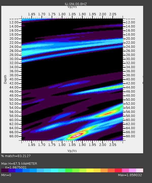
| Estimated Moho Depth: |
67.5 km |
| Estimated Crust Vp/Vs: |
1.87 |
| Assumed Crust Vp: |
6.291 km/s |
| Estimated Crust Vs: |
3.369 km/s |
| Estimated Crust Poisson's Ratio: |
0.30 |
|
| Radial Match: |
83.2127 % |
| Radial Bump: |
270 |
| Transverse Match: |
83.74953 % |
| Transverse Bump: |
377 |
| SOD ConfigId: |
558545 |
| Insert Time: |
2013-09-18 12:15:19.108 +0000 |
| GWidth: |
2.5 |
| Max Bumps: |
400 |
| Tol: |
0.001 |
|

Signal To Noise
| Channel | StoN | STA | LTA |
| IU:GNI:00:BHZ:20110311T11:32:21.769004Z | 1.6383686 | 2.3991722E-6 | 1.4643666E-6 |
| IU:GNI:00:BH1:20110311T11:32:21.769004Z | 1.6019582 | 4.2986726E-6 | 2.6833861E-6 |
| IU:GNI:00:BH2:20110311T11:32:21.769004Z | 1.3598891 | 1.9832398E-6 | 1.4583835E-6 |
| Arrivals |
| Ps | 9.6 SECOND |
| PpPs | 30 SECOND |
| PsPs/PpSs | 39 SECOND |


