You are here: Home > Network List > TA - USArray Transportable Network (new EarthScope stations) Stations List
> Station MSTX Muleshoe, TX, USA > Earthquake Result Viewer
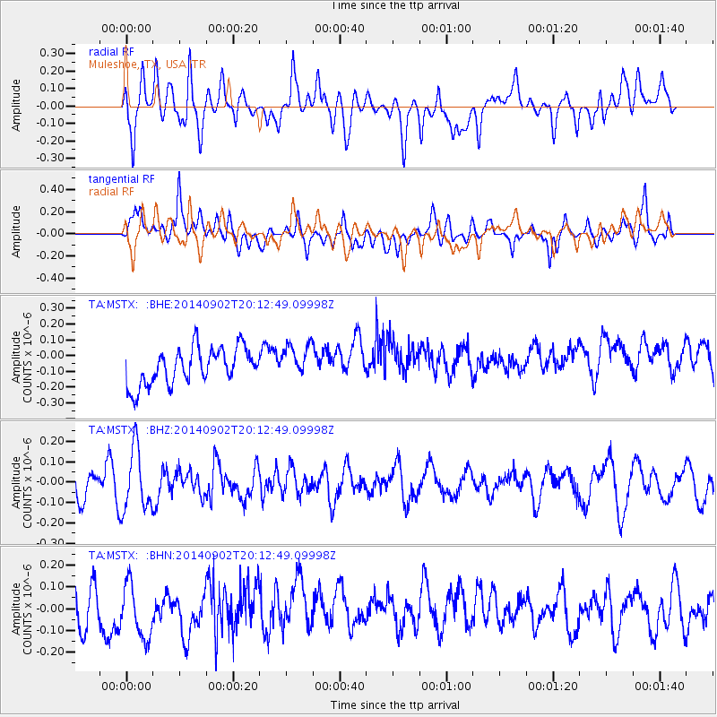
MSTX Muleshoe, TX, USA - Earthquake Result Viewer
*The percent match for this event was below the threshold and hence no stack was calculated.
| Earthquake location: |
Kermadec Islands Region |
| Earthquake latitude/longitude: |
-28.0/-176.6 |
| Earthquake time(UTC): |
2014/09/02 (245) 20:00:10 GMT |
| Earthquake Depth: |
37 km |
| Earthquake Magnitude: |
5.4 MW |
| Earthquake Catalog/Contributor: |
ISC/ISC |
|
| Network: |
TA USArray Transportable Network (new EarthScope stations) |
| Station: |
MSTX Muleshoe, TX, USA |
| Lat/Lon: |
33.97 N/102.77 W |
| Elevation: |
1167 m |
|
| Distance: |
93.1 deg |
| Az: |
53.051 deg |
| Baz: |
238.275 deg |
| Ray Param: |
$rayparam |
*The percent match for this event was below the threshold and hence was not used in the summary stack. |
|
| Radial Match: |
50.36286 % |
| Radial Bump: |
400 |
| Transverse Match: |
53.025764 % |
| Transverse Bump: |
400 |
| SOD ConfigId: |
3390531 |
| Insert Time: |
2019-04-13 18:54:17.263 +0000 |
| GWidth: |
2.5 |
| Max Bumps: |
400 |
| Tol: |
0.001 |
|
Signal To Noise
| Channel | StoN | STA | LTA |
| TA:MSTX: :BHZ:20140902T20:12:49.09998Z | 2.4512324 | 1.4882653E-7 | 6.071498E-8 |
| TA:MSTX: :BHN:20140902T20:12:49.09998Z | 1.3419553 | 1.2528274E-7 | 9.335835E-8 |
| TA:MSTX: :BHE:20140902T20:12:49.09998Z | 0.952731 | 1.0974895E-7 | 1.1519406E-7 |
| Arrivals |
| Ps | |
| PpPs | |
| PsPs/PpSs | |


