You are here: Home > Network List > US - United States National Seismic Network Stations List
> Station WMOK Wichita Mountains, Oklahoma, USA > Earthquake Result Viewer
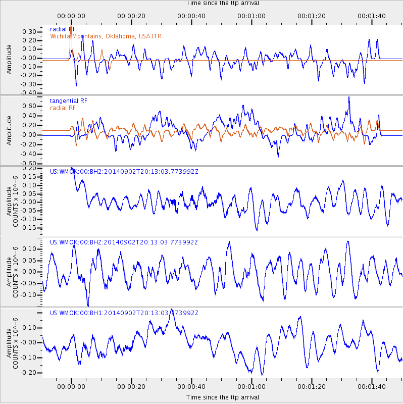
WMOK Wichita Mountains, Oklahoma, USA - Earthquake Result Viewer
*The percent match for this event was below the threshold and hence no stack was calculated.
| Earthquake location: |
Kermadec Islands Region |
| Earthquake latitude/longitude: |
-28.0/-176.6 |
| Earthquake time(UTC): |
2014/09/02 (245) 20:00:10 GMT |
| Earthquake Depth: |
37 km |
| Earthquake Magnitude: |
5.4 MW |
| Earthquake Catalog/Contributor: |
ISC/ISC |
|
| Network: |
US United States National Seismic Network |
| Station: |
WMOK Wichita Mountains, Oklahoma, USA |
| Lat/Lon: |
34.74 N/98.78 W |
| Elevation: |
486 m |
|
| Distance: |
96.3 deg |
| Az: |
54.079 deg |
| Baz: |
240.433 deg |
| Ray Param: |
$rayparam |
*The percent match for this event was below the threshold and hence was not used in the summary stack. |
|
| Radial Match: |
58.718555 % |
| Radial Bump: |
400 |
| Transverse Match: |
36.59941 % |
| Transverse Bump: |
400 |
| SOD ConfigId: |
3390531 |
| Insert Time: |
2019-04-13 18:54:54.569 +0000 |
| GWidth: |
2.5 |
| Max Bumps: |
400 |
| Tol: |
0.001 |
|
Signal To Noise
| Channel | StoN | STA | LTA |
| US:WMOK:00:BHZ:20140902T20:13:03.773992Z | 0.964584 | 5.591073E-8 | 5.7963568E-8 |
| US:WMOK:00:BH1:20140902T20:13:03.773992Z | 0.5859385 | 7.145887E-8 | 1.2195626E-7 |
| US:WMOK:00:BH2:20140902T20:13:03.773992Z | 0.59545946 | 3.4249176E-8 | 5.7517227E-8 |
| Arrivals |
| Ps | |
| PpPs | |
| PsPs/PpSs | |


