You are here: Home > Network List > IU - Global Seismograph Network (GSN - IRIS/USGS) Stations List
> Station POHA Pohakuloa, Hawaii, USA > Earthquake Result Viewer
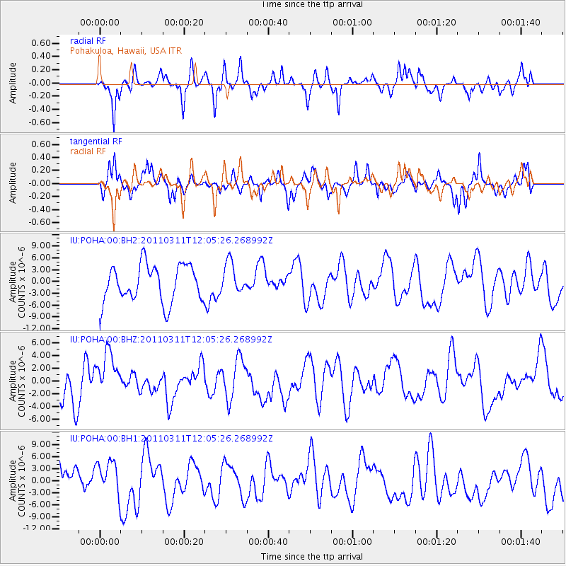
POHA Pohakuloa, Hawaii, USA - Earthquake Result Viewer
*The percent match for this event was below the threshold and hence no stack was calculated.
| Earthquake location: |
Near East Coast Of Honshu, Japan |
| Earthquake latitude/longitude: |
36.3/141.5 |
| Earthquake time(UTC): |
2011/03/11 (070) 11:56:13 GMT |
| Earthquake Depth: |
23 km |
| Earthquake Magnitude: |
5.5 MB |
| Earthquake Catalog/Contributor: |
WHDF/NEIC |
|
| Network: |
IU Global Seismograph Network (GSN - IRIS/USGS) |
| Station: |
POHA Pohakuloa, Hawaii, USA |
| Lat/Lon: |
19.76 N/155.53 W |
| Elevation: |
1990 m |
|
| Distance: |
57.0 deg |
| Az: |
88.688 deg |
| Baz: |
300.926 deg |
| Ray Param: |
$rayparam |
*The percent match for this event was below the threshold and hence was not used in the summary stack. |
|
| Radial Match: |
58.84416 % |
| Radial Bump: |
357 |
| Transverse Match: |
63.096077 % |
| Transverse Bump: |
356 |
| SOD ConfigId: |
558545 |
| Insert Time: |
2013-09-18 12:23:29.996 +0000 |
| GWidth: |
2.5 |
| Max Bumps: |
400 |
| Tol: |
0.001 |
|
Signal To Noise
| Channel | StoN | STA | LTA |
| IU:POHA:00:BHZ:20110311T12:05:26.268992Z | 1.3696576 | 4.284159E-6 | 3.127905E-6 |
| IU:POHA:00:BH1:20110311T12:05:26.268992Z | 0.9410412 | 4.3971345E-6 | 4.6726273E-6 |
| IU:POHA:00:BH2:20110311T12:05:26.268992Z | 0.85889506 | 4.047344E-6 | 4.7122685E-6 |
| Arrivals |
| Ps | |
| PpPs | |
| PsPs/PpSs | |


