You are here: Home > Network List > II - Global Seismograph Network (GSN - IRIS/IDA) Stations List
> Station WRAB Tennant Creek, NT, Australia > Earthquake Result Viewer
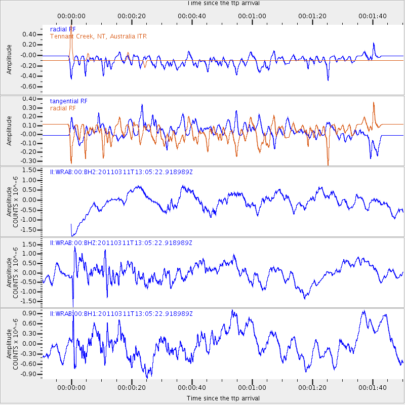
WRAB Tennant Creek, NT, Australia - Earthquake Result Viewer
*The percent match for this event was below the threshold and hence no stack was calculated.
| Earthquake location: |
Near East Coast Of Honshu, Japan |
| Earthquake latitude/longitude: |
37.8/142.0 |
| Earthquake time(UTC): |
2011/03/11 (070) 12:56:05 GMT |
| Earthquake Depth: |
35 km |
| Earthquake Magnitude: |
5.5 MB |
| Earthquake Catalog/Contributor: |
NEIC PDE/NEIC PDE-M |
|
| Network: |
II Global Seismograph Network (GSN - IRIS/IDA) |
| Station: |
WRAB Tennant Creek, NT, Australia |
| Lat/Lon: |
19.93 S/134.36 E |
| Elevation: |
366 m |
|
| Distance: |
57.9 deg |
| Az: |
188.45 deg |
| Baz: |
7.107 deg |
| Ray Param: |
$rayparam |
*The percent match for this event was below the threshold and hence was not used in the summary stack. |
|
| Radial Match: |
72.65229 % |
| Radial Bump: |
400 |
| Transverse Match: |
51.910458 % |
| Transverse Bump: |
400 |
| SOD ConfigId: |
558545 |
| Insert Time: |
2013-09-18 12:29:47.460 +0000 |
| GWidth: |
2.5 |
| Max Bumps: |
400 |
| Tol: |
0.001 |
|
Signal To Noise
| Channel | StoN | STA | LTA |
| II:WRAB:00:BHZ:20110311T13:05:22.918989Z | 1.7380154 | 7.5745874E-7 | 4.3581818E-7 |
| II:WRAB:00:BH1:20110311T13:05:22.918989Z | 0.92918295 | 7.117014E-7 | 7.6594324E-7 |
| II:WRAB:00:BH2:20110311T13:05:22.918989Z | 0.32106048 | 2.1368582E-7 | 6.6556254E-7 |
| Arrivals |
| Ps | |
| PpPs | |
| PsPs/PpSs | |


