You are here: Home > Network List > IU - Global Seismograph Network (GSN - IRIS/USGS) Stations List
> Station RSSD Black Hills, South Dakota, USA > Earthquake Result Viewer
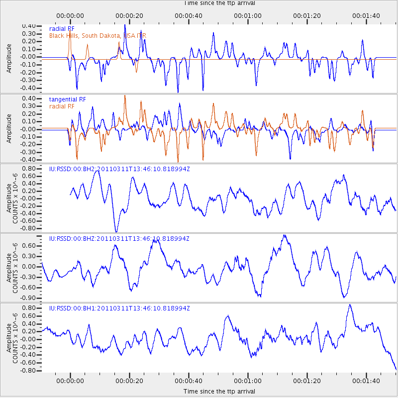
RSSD Black Hills, South Dakota, USA - Earthquake Result Viewer
*The percent match for this event was below the threshold and hence no stack was calculated.
| Earthquake location: |
Near East Coast Of Honshu, Japan |
| Earthquake latitude/longitude: |
36.2/141.8 |
| Earthquake time(UTC): |
2011/03/11 (070) 13:34:30 GMT |
| Earthquake Depth: |
4.7 km |
| Earthquake Magnitude: |
5.5 MB |
| Earthquake Catalog/Contributor: |
WHDF/NEIC |
|
| Network: |
IU Global Seismograph Network (GSN - IRIS/USGS) |
| Station: |
RSSD Black Hills, South Dakota, USA |
| Lat/Lon: |
44.12 N/104.04 W |
| Elevation: |
2090 m |
|
| Distance: |
80.2 deg |
| Az: |
41.831 deg |
| Baz: |
311.463 deg |
| Ray Param: |
$rayparam |
*The percent match for this event was below the threshold and hence was not used in the summary stack. |
|
| Radial Match: |
45.64719 % |
| Radial Bump: |
344 |
| Transverse Match: |
44.7812 % |
| Transverse Bump: |
400 |
| SOD ConfigId: |
558545 |
| Insert Time: |
2013-09-18 12:34:03.542 +0000 |
| GWidth: |
2.5 |
| Max Bumps: |
400 |
| Tol: |
0.001 |
|
Signal To Noise
| Channel | StoN | STA | LTA |
| IU:RSSD:00:BHZ:20110311T13:46:10.818994Z | 0.66553503 | 2.1169603E-7 | 3.1808398E-7 |
| IU:RSSD:00:BH1:20110311T13:46:10.818994Z | 0.5554716 | 1.6808593E-7 | 3.0260043E-7 |
| IU:RSSD:00:BH2:20110311T13:46:10.818994Z | 0.6503789 | 2.4395104E-7 | 3.7509062E-7 |
| Arrivals |
| Ps | |
| PpPs | |
| PsPs/PpSs | |


