You are here: Home > Network List > TA - USArray Transportable Network (new EarthScope stations) Stations List
> Station O48A Farmland, IN, USA > Earthquake Result Viewer
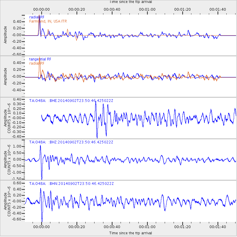
O48A Farmland, IN, USA - Earthquake Result Viewer
*The percent match for this event was below the threshold and hence no stack was calculated.
| Earthquake location: |
Central East Pacific Rise |
| Earthquake latitude/longitude: |
-11.6/-112.0 |
| Earthquake time(UTC): |
2014/09/02 (245) 23:41:31 GMT |
| Earthquake Depth: |
10 km |
| Earthquake Magnitude: |
5.5 MWP |
| Earthquake Catalog/Contributor: |
NEIC PDE/NEIC COMCAT |
|
| Network: |
TA USArray Transportable Network (new EarthScope stations) |
| Station: |
O48A Farmland, IN, USA |
| Lat/Lon: |
40.26 N/85.16 W |
| Elevation: |
300 m |
|
| Distance: |
57.3 deg |
| Az: |
24.264 deg |
| Baz: |
211.748 deg |
| Ray Param: |
$rayparam |
*The percent match for this event was below the threshold and hence was not used in the summary stack. |
|
| Radial Match: |
71.175705 % |
| Radial Bump: |
400 |
| Transverse Match: |
48.888542 % |
| Transverse Bump: |
400 |
| SOD ConfigId: |
3390531 |
| Insert Time: |
2019-04-13 19:01:41.439 +0000 |
| GWidth: |
2.5 |
| Max Bumps: |
400 |
| Tol: |
0.001 |
|
Signal To Noise
| Channel | StoN | STA | LTA |
| TA:O48A: :BHZ:20140902T23:50:46.425022Z | 11.06467 | 5.8709463E-7 | 5.3060294E-8 |
| TA:O48A: :BHN:20140902T23:50:46.425022Z | 3.418861 | 2.6594216E-7 | 7.778677E-8 |
| TA:O48A: :BHE:20140902T23:50:46.425022Z | 3.3838425 | 1.9435696E-7 | 5.743676E-8 |
| Arrivals |
| Ps | |
| PpPs | |
| PsPs/PpSs | |


