You are here: Home > Network List > II - Global Seismograph Network (GSN - IRIS/IDA) Stations List
> Station KAPI Kappang, Sulawesi, Indonesia > Earthquake Result Viewer
KAPI Kappang, Sulawesi, Indonesia - Earthquake Result Viewer

| Earthquake location: |
Near East Coast Of Honshu, Japan |
| Earthquake latitude/longitude: |
36.0/141.8 |
| Earthquake time(UTC): |
2011/03/11 (070) 15:13:14 GMT |
| Earthquake Depth: |
21 km |
| Earthquake Magnitude: |
6.2 MB, 6.3 MW, 6.3 MS |
| Earthquake Catalog/Contributor: |
NEIC PDE/NEIC PDE-M |
|
| Network: |
II Global Seismograph Network (GSN - IRIS/IDA) |
| Station: |
KAPI Kappang, Sulawesi, Indonesia |
| Lat/Lon: |
5.01 S/119.75 E |
| Elevation: |
300 m |
|
| Distance: |
45.7 deg |
| Az: |
211.492 deg |
| Baz: |
25.166 deg |
| Ray Param: |
0.071051106 |
| Estimated Moho Depth: |
69.5 km |
| Estimated Crust Vp/Vs: |
2.07 |
| Assumed Crust Vp: |
6.343 km/s |
| Estimated Crust Vs: |
3.064 km/s |
| Estimated Crust Poisson's Ratio: |
0.35 |
|
| Radial Match: |
92.99948 % |
| Radial Bump: |
400 |
| Transverse Match: |
94.64554 % |
| Transverse Bump: |
400 |
| SOD ConfigId: |
558545 |
| Insert Time: |
2013-09-18 12:41:29.995 +0000 |
| GWidth: |
2.5 |
| Max Bumps: |
400 |
| Tol: |
0.001 |
|
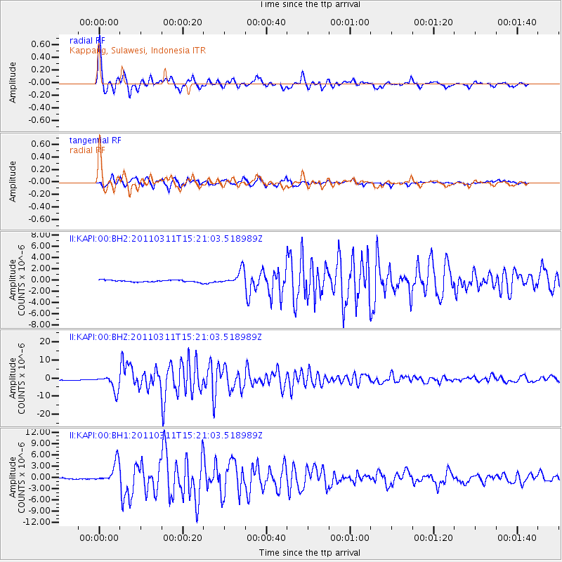
Signal To Noise
| Channel | StoN | STA | LTA |
| II:KAPI:00:BHZ:20110311T15:21:03.518989Z | 8.972775 | 4.654779E-6 | 5.187669E-7 |
| II:KAPI:00:BH1:20110311T15:21:03.518989Z | 6.050255 | 2.9599682E-6 | 4.8923033E-7 |
| II:KAPI:00:BH2:20110311T15:21:03.518989Z | 8.153643 | 1.3798806E-6 | 1.6923487E-7 |
| Arrivals |
| Ps | 12 SECOND |
| PpPs | 32 SECOND |
| PsPs/PpSs | 44 SECOND |


