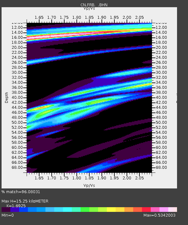
FRB IQALUIT, N.W.T. - Earthquake Result Viewer

Earthquake location: Near Coast Of Guerrero, Mexico
Earthquake latitude/longitude: 16.3/-98.2
Earthquake time(UTC): 1997/07/19 (200) 14:22:08 GMT
Earthquake Depth: 33 km
Earthquake Magnitude: 5.7 MB, 6.3 MS, 6.8 UNKNOWN, 6.0 ME
Earthquake Catalog/Contributor: WHDF/NEIC
Network: CN Canadian National Seismograph Network
Station: FRB IQALUIT, N.W.T.
Lat/Lon: 63.75 N/68.55 W
Elevation: 18 m
Distance: 51.6 deg
Az: 16.317 deg
Baz: 217.342 deg
Ray Param: 0.067255214
Estimated Moho Depth: 15.25 km
Estimated Crust Vp/Vs: 1.69
Assumed Crust Vp: 6.419 km/s
Estimated Crust Vs: 3.793 km/s
Estimated Crust Poisson's Ratio: 0.23
Radial Match: 96.08031 %
Radial Bump: 400
Transverse Match: 81.168175 %
Transverse Bump: 400
SOD ConfigId: 6273
Insert Time: 2010-02-27 05:50:02.682 +0000
GWidth: 2.5
Max Bumps: 400
Tol: 0.001

Signal To Noise

ChannelStoNSTALTA
CN:FRB: :BHN:19970719T14:30:41.100024Z1.10907671495.05471348.0173
CN:FRB: :BHE:19970719T14:30:41.100024Z2.24980243760.00441671.2598
CN:FRB: :BHZ:19970719T14:30:41.100024Z1.4572935885.04934038.3428
Arrivals
Ps1.7 SECOND
PpPs6.0 SECOND
PsPs/PpSs7.8 SECOND