You are here: Home > Network List > IU - Global Seismograph Network (GSN - IRIS/USGS) Stations List
> Station MAKZ Makanchi, Kazakhstan > Earthquake Result Viewer
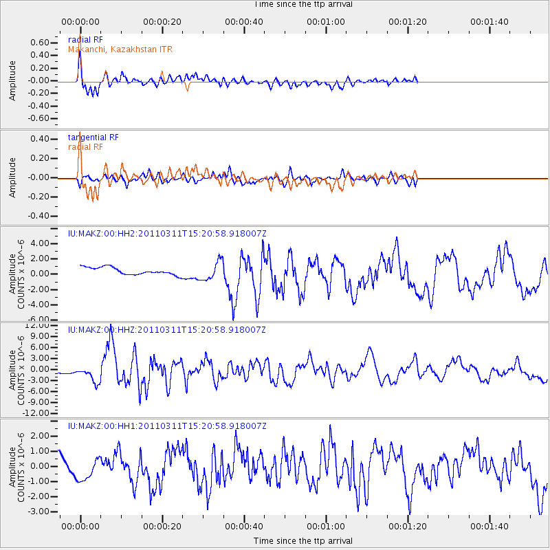
MAKZ Makanchi, Kazakhstan - Earthquake Result Viewer
*The percent match for this event was below the threshold and hence no stack was calculated.
| Earthquake location: |
Near East Coast Of Honshu, Japan |
| Earthquake latitude/longitude: |
36.0/141.8 |
| Earthquake time(UTC): |
2011/03/11 (070) 15:13:14 GMT |
| Earthquake Depth: |
21 km |
| Earthquake Magnitude: |
6.2 MB, 6.3 MW, 6.3 MS |
| Earthquake Catalog/Contributor: |
NEIC PDE/NEIC PDE-M |
|
| Network: |
IU Global Seismograph Network (GSN - IRIS/USGS) |
| Station: |
MAKZ Makanchi, Kazakhstan |
| Lat/Lon: |
46.81 N/81.98 E |
| Elevation: |
600 m |
|
| Distance: |
45.2 deg |
| Az: |
303.118 deg |
| Baz: |
81.425 deg |
| Ray Param: |
$rayparam |
*The percent match for this event was below the threshold and hence was not used in the summary stack. |
|
| Radial Match: |
78.302765 % |
| Radial Bump: |
358 |
| Transverse Match: |
51.76916 % |
| Transverse Bump: |
392 |
| SOD ConfigId: |
558545 |
| Insert Time: |
2013-09-18 12:42:15.505 +0000 |
| GWidth: |
2.5 |
| Max Bumps: |
400 |
| Tol: |
0.001 |
|
Signal To Noise
| Channel | StoN | STA | LTA |
| IU:MAKZ:00:HHZ:20110311T15:20:58.918007Z | 5.771133 | 2.1751903E-6 | 3.769087E-7 |
| IU:MAKZ:00:HH1:20110311T15:20:58.918007Z | 0.9383793 | 7.390739E-7 | 7.8760684E-7 |
| IU:MAKZ:00:HH2:20110311T15:20:58.918007Z | 2.6606078 | 1.2636285E-6 | 4.749398E-7 |
| Arrivals |
| Ps | |
| PpPs | |
| PsPs/PpSs | |


