You are here: Home > Network List > IU - Global Seismograph Network (GSN - IRIS/USGS) Stations List
> Station RSSD Black Hills, South Dakota, USA > Earthquake Result Viewer
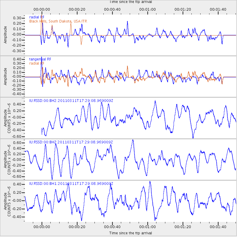
RSSD Black Hills, South Dakota, USA - Earthquake Result Viewer
*The percent match for this event was below the threshold and hence no stack was calculated.
| Earthquake location: |
Near East Coast Of Honshu, Japan |
| Earthquake latitude/longitude: |
35.3/141.4 |
| Earthquake time(UTC): |
2011/03/11 (070) 17:17:23 GMT |
| Earthquake Depth: |
1.7 km |
| Earthquake Magnitude: |
5.5 MB |
| Earthquake Catalog/Contributor: |
WHDF/NEIC |
|
| Network: |
IU Global Seismograph Network (GSN - IRIS/USGS) |
| Station: |
RSSD Black Hills, South Dakota, USA |
| Lat/Lon: |
44.12 N/104.04 W |
| Elevation: |
2090 m |
|
| Distance: |
81.1 deg |
| Az: |
41.524 deg |
| Baz: |
311.181 deg |
| Ray Param: |
$rayparam |
*The percent match for this event was below the threshold and hence was not used in the summary stack. |
|
| Radial Match: |
59.220013 % |
| Radial Bump: |
400 |
| Transverse Match: |
56.040825 % |
| Transverse Bump: |
387 |
| SOD ConfigId: |
558545 |
| Insert Time: |
2013-09-18 12:48:54.105 +0000 |
| GWidth: |
2.5 |
| Max Bumps: |
400 |
| Tol: |
0.001 |
|
Signal To Noise
| Channel | StoN | STA | LTA |
| IU:RSSD:00:BHZ:20110311T17:29:08.969009Z | 0.9466789 | 2.789179E-7 | 2.9462777E-7 |
| IU:RSSD:00:BH1:20110311T17:29:08.969009Z | 0.83275604 | 1.6880452E-7 | 2.0270585E-7 |
| IU:RSSD:00:BH2:20110311T17:29:08.969009Z | 1.2747756 | 2.7551943E-7 | 2.1613171E-7 |
| Arrivals |
| Ps | |
| PpPs | |
| PsPs/PpSs | |


