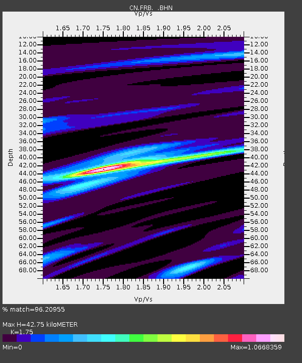
FRB IQALUIT, N.W.T. - Earthquake Result Viewer
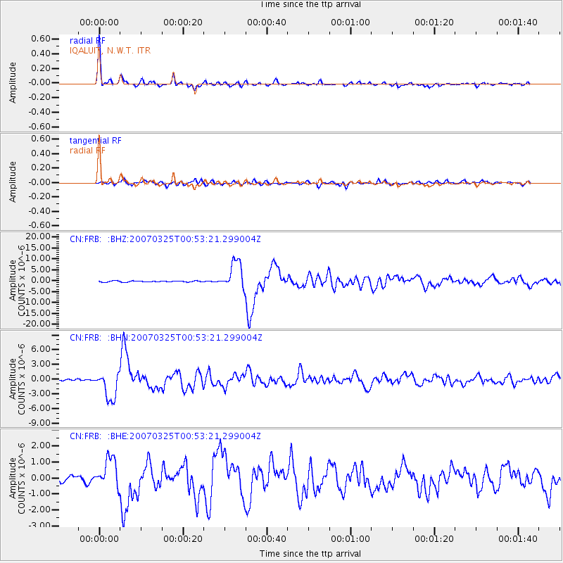
Earthquake location: Near West Coast Of Honshu, Japan
Earthquake latitude/longitude: 37.3/136.6
Earthquake time(UTC): 2007/03/25 (084) 00:41:57 GMT
Earthquake Depth: 8.0 km
Earthquake Magnitude: 6.1 MB, 6.8 MS, 6.7 MW, 6.6 MW
Earthquake Catalog/Contributor: WHDF/NEIC
Network: CN Canadian National Seismograph Network
Station: FRB IQALUIT, N.W.T.
Lat/Lon: 63.75 N/68.55 W
Elevation: 18 m
Distance: 77.3 deg
Az: 11.165 deg
Baz: 339.693 deg
Ray Param: 0.05042561
Estimated Moho Depth: 42.75 km
Estimated Crust Vp/Vs: 1.75
Assumed Crust Vp: 6.419 km/s
Estimated Crust Vs: 3.668 km/s
Estimated Crust Poisson's Ratio: 0.26
Radial Match: 96.20955 %
Radial Bump: 354
Transverse Match: 87.81919 %
Transverse Bump: 400
SOD ConfigId: 2564
Insert Time: 2010-02-27 05:50:43.749 +0000
GWidth: 2.5
Max Bumps: 400
Tol: 0.001

Signal To Noise

ChannelStoNSTALTA
CN:FRB: :BHN:20070325T00:53:21.299004Z9.85133652.8542058E-62.8972775E-7
CN:FRB: :BHE:20070325T00:53:21.299004Z4.75167379.0919826E-71.9134274E-7
CN:FRB: :BHZ:20070325T00:53:21.299004Z25.8690596.5905974E-62.547676E-7
Arrivals
Ps5.2 SECOND
PpPs18 SECOND
PsPs/PpSs23 SECOND