You are here: Home > Network List > IU - Global Seismograph Network (GSN - IRIS/USGS) Stations List
> Station MAKZ Makanchi, Kazakhstan > Earthquake Result Viewer
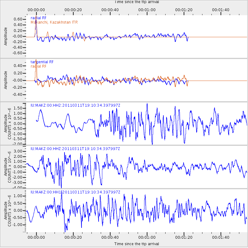
MAKZ Makanchi, Kazakhstan - Earthquake Result Viewer
*The percent match for this event was below the threshold and hence no stack was calculated.
| Earthquake location: |
Near East Coast Of Honshu, Japan |
| Earthquake latitude/longitude: |
39.3/142.9 |
| Earthquake time(UTC): |
2011/03/11 (070) 19:02:59 GMT |
| Earthquake Depth: |
27 km |
| Earthquake Magnitude: |
6.1 MB, 6.2 MS, 6.0 MW |
| Earthquake Catalog/Contributor: |
WHDF/NEIC |
|
| Network: |
IU Global Seismograph Network (GSN - IRIS/USGS) |
| Station: |
MAKZ Makanchi, Kazakhstan |
| Lat/Lon: |
46.81 N/81.98 E |
| Elevation: |
600 m |
|
| Distance: |
44.1 deg |
| Az: |
300.436 deg |
| Baz: |
76.748 deg |
| Ray Param: |
$rayparam |
*The percent match for this event was below the threshold and hence was not used in the summary stack. |
|
| Radial Match: |
64.29455 % |
| Radial Bump: |
400 |
| Transverse Match: |
60.28545 % |
| Transverse Bump: |
400 |
| SOD ConfigId: |
558545 |
| Insert Time: |
2013-09-18 12:54:36.774 +0000 |
| GWidth: |
2.5 |
| Max Bumps: |
400 |
| Tol: |
0.001 |
|
Signal To Noise
| Channel | StoN | STA | LTA |
| IU:MAKZ:00:HHZ:20110311T19:10:34.397997Z | 2.0437853 | 1.0372215E-6 | 5.075002E-7 |
| IU:MAKZ:00:HH1:20110311T19:10:34.397997Z | 1.4515452 | 3.8045786E-7 | 2.621054E-7 |
| IU:MAKZ:00:HH2:20110311T19:10:34.397997Z | 1.3128798 | 6.696956E-7 | 5.1009664E-7 |
| Arrivals |
| Ps | |
| PpPs | |
| PsPs/PpSs | |


