You are here: Home > Network List > IU - Global Seismograph Network (GSN - IRIS/USGS) Stations List
> Station PMG Port Moresby, New Guinea > Earthquake Result Viewer
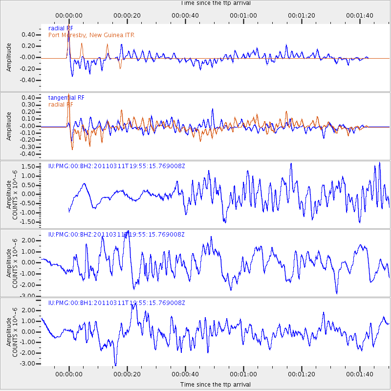
PMG Port Moresby, New Guinea - Earthquake Result Viewer
*The percent match for this event was below the threshold and hence no stack was calculated.
| Earthquake location: |
Near West Coast Of Honshu, Japan |
| Earthquake latitude/longitude: |
40.5/139.1 |
| Earthquake time(UTC): |
2011/03/11 (070) 19:46:50 GMT |
| Earthquake Depth: |
10 km |
| Earthquake Magnitude: |
6.2 MB, 6.1 MS, 6.2 MW |
| Earthquake Catalog/Contributor: |
WHDF/NEIC |
|
| Network: |
IU Global Seismograph Network (GSN - IRIS/USGS) |
| Station: |
PMG Port Moresby, New Guinea |
| Lat/Lon: |
9.40 S/147.16 E |
| Elevation: |
90 m |
|
| Distance: |
50.2 deg |
| Az: |
169.568 deg |
| Baz: |
351.954 deg |
| Ray Param: |
$rayparam |
*The percent match for this event was below the threshold and hence was not used in the summary stack. |
|
| Radial Match: |
66.47536 % |
| Radial Bump: |
400 |
| Transverse Match: |
56.978706 % |
| Transverse Bump: |
400 |
| SOD ConfigId: |
558545 |
| Insert Time: |
2013-09-18 12:59:13.294 +0000 |
| GWidth: |
2.5 |
| Max Bumps: |
400 |
| Tol: |
0.001 |
|
Signal To Noise
| Channel | StoN | STA | LTA |
| IU:PMG:00:BHZ:20110311T19:55:15.769008Z | 1.7930832 | 7.281051E-7 | 4.060632E-7 |
| IU:PMG:00:BH1:20110311T19:55:15.769008Z | 0.63756084 | 3.5872864E-7 | 5.6265793E-7 |
| IU:PMG:00:BH2:20110311T19:55:15.769008Z | 0.30697027 | 9.946098E-8 | 3.2400854E-7 |
| Arrivals |
| Ps | |
| PpPs | |
| PsPs/PpSs | |


