You are here: Home > Network List > IU - Global Seismograph Network (GSN - IRIS/USGS) Stations List
> Station MAKZ Makanchi, Kazakhstan > Earthquake Result Viewer
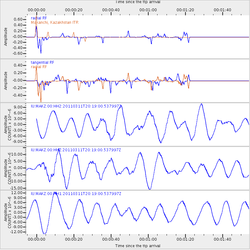
MAKZ Makanchi, Kazakhstan - Earthquake Result Viewer
*The percent match for this event was below the threshold and hence no stack was calculated.
| Earthquake location: |
Near East Coast Of Honshu, Japan |
| Earthquake latitude/longitude: |
39.0/142.6 |
| Earthquake time(UTC): |
2011/03/11 (070) 20:11:24 GMT |
| Earthquake Depth: |
17 km |
| Earthquake Magnitude: |
5.9 MB, 5.8 MS, 6.1 MW |
| Earthquake Catalog/Contributor: |
WHDF/NEIC |
|
| Network: |
IU Global Seismograph Network (GSN - IRIS/USGS) |
| Station: |
MAKZ Makanchi, Kazakhstan |
| Lat/Lon: |
46.81 N/81.98 E |
| Elevation: |
600 m |
|
| Distance: |
44.1 deg |
| Az: |
300.682 deg |
| Baz: |
77.3 deg |
| Ray Param: |
$rayparam |
*The percent match for this event was below the threshold and hence was not used in the summary stack. |
|
| Radial Match: |
64.5253 % |
| Radial Bump: |
284 |
| Transverse Match: |
65.179504 % |
| Transverse Bump: |
313 |
| SOD ConfigId: |
558545 |
| Insert Time: |
2013-09-18 13:00:21.001 +0000 |
| GWidth: |
2.5 |
| Max Bumps: |
400 |
| Tol: |
0.001 |
|
Signal To Noise
| Channel | StoN | STA | LTA |
| IU:MAKZ:00:HHZ:20110311T20:19:00.537997Z | 0.70087683 | 2.7843028E-6 | 3.972599E-6 |
| IU:MAKZ:00:HH1:20110311T20:19:00.537997Z | 1.9671584 | 8.451403E-6 | 4.2962492E-6 |
| IU:MAKZ:00:HH2:20110311T20:19:00.537997Z | 0.45792085 | 1.9488916E-6 | 4.2559577E-6 |
| Arrivals |
| Ps | |
| PpPs | |
| PsPs/PpSs | |


