You are here: Home > Network List > IU - Global Seismograph Network (GSN - IRIS/USGS) Stations List
> Station RSSD Black Hills, South Dakota, USA > Earthquake Result Viewer
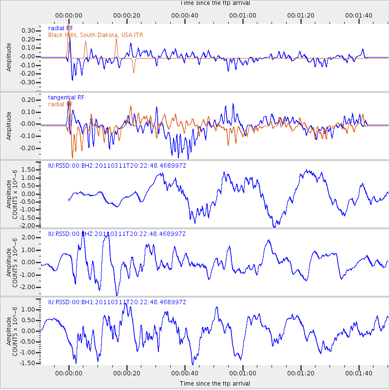
RSSD Black Hills, South Dakota, USA - Earthquake Result Viewer
*The percent match for this event was below the threshold and hence no stack was calculated.
| Earthquake location: |
Near East Coast Of Honshu, Japan |
| Earthquake latitude/longitude: |
39.0/142.6 |
| Earthquake time(UTC): |
2011/03/11 (070) 20:11:24 GMT |
| Earthquake Depth: |
17 km |
| Earthquake Magnitude: |
5.9 MB, 5.8 MS, 6.1 MW |
| Earthquake Catalog/Contributor: |
WHDF/NEIC |
|
| Network: |
IU Global Seismograph Network (GSN - IRIS/USGS) |
| Station: |
RSSD Black Hills, South Dakota, USA |
| Lat/Lon: |
44.12 N/104.04 W |
| Elevation: |
2090 m |
|
| Distance: |
77.7 deg |
| Az: |
42.593 deg |
| Baz: |
312.93 deg |
| Ray Param: |
$rayparam |
*The percent match for this event was below the threshold and hence was not used in the summary stack. |
|
| Radial Match: |
56.63298 % |
| Radial Bump: |
400 |
| Transverse Match: |
33.07796 % |
| Transverse Bump: |
381 |
| SOD ConfigId: |
558545 |
| Insert Time: |
2013-09-18 13:00:31.166 +0000 |
| GWidth: |
2.5 |
| Max Bumps: |
400 |
| Tol: |
0.001 |
|
Signal To Noise
| Channel | StoN | STA | LTA |
| IU:RSSD:00:BHZ:20110311T20:22:48.468997Z | 3.72624 | 1.1203477E-6 | 3.0066442E-7 |
| IU:RSSD:00:BH1:20110311T20:22:48.468997Z | 3.5171554 | 7.897616E-7 | 2.2454556E-7 |
| IU:RSSD:00:BH2:20110311T20:22:48.468997Z | 4.255695 | 1.1304259E-6 | 2.6562662E-7 |
| Arrivals |
| Ps | |
| PpPs | |
| PsPs/PpSs | |


