You are here: Home > Network List > II - Global Seismograph Network (GSN - IRIS/IDA) Stations List
> Station PFO Pinon Flat, California, USA > Earthquake Result Viewer
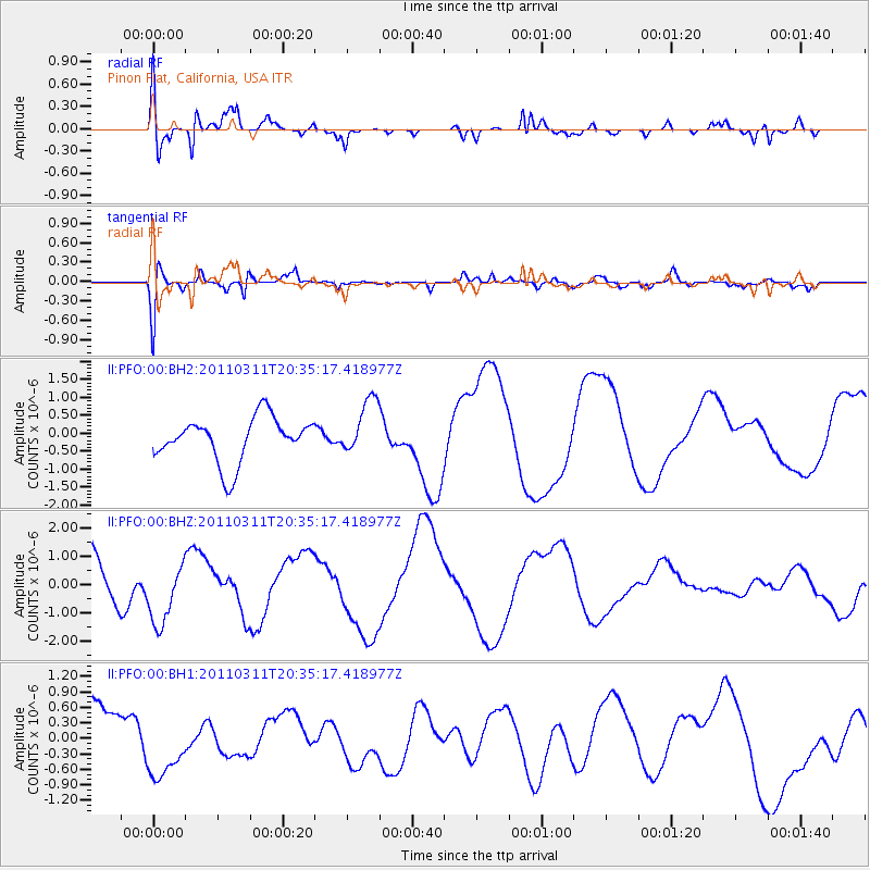
PFO Pinon Flat, California, USA - Earthquake Result Viewer
*The percent match for this event was below the threshold and hence no stack was calculated.
| Earthquake location: |
Near East Coast Of Honshu, Japan |
| Earthquake latitude/longitude: |
35.8/141.6 |
| Earthquake time(UTC): |
2011/03/11 (070) 20:23:41 GMT |
| Earthquake Depth: |
8.1 km |
| Earthquake Magnitude: |
5.5 MB, 5.7 MS |
| Earthquake Catalog/Contributor: |
WHDF/NEIC |
|
| Network: |
II Global Seismograph Network (GSN - IRIS/IDA) |
| Station: |
PFO Pinon Flat, California, USA |
| Lat/Lon: |
33.61 N/116.46 W |
| Elevation: |
1280 m |
|
| Distance: |
79.6 deg |
| Az: |
56.112 deg |
| Baz: |
306.05 deg |
| Ray Param: |
$rayparam |
*The percent match for this event was below the threshold and hence was not used in the summary stack. |
|
| Radial Match: |
65.81095 % |
| Radial Bump: |
400 |
| Transverse Match: |
71.64571 % |
| Transverse Bump: |
400 |
| SOD ConfigId: |
558545 |
| Insert Time: |
2013-09-18 13:01:07.900 +0000 |
| GWidth: |
2.5 |
| Max Bumps: |
400 |
| Tol: |
0.001 |
|
Signal To Noise
| Channel | StoN | STA | LTA |
| II:PFO:00:BHZ:20110311T20:35:17.418977Z | 1.5332904 | 1.0398702E-6 | 6.7819525E-7 |
| II:PFO:00:BH1:20110311T20:35:17.418977Z | 1.353975 | 7.6228764E-7 | 5.6299973E-7 |
| II:PFO:00:BH2:20110311T20:35:17.418977Z | 1.274358 | 7.8492457E-7 | 6.1593727E-7 |
| Arrivals |
| Ps | |
| PpPs | |
| PsPs/PpSs | |


