You are here: Home > Network List > ZW13 - Locating North Texas Earthquakes Stations List
> Station AZLE Azle B2 > Earthquake Result Viewer
AZLE Azle B2 - Earthquake Result Viewer
| Earthquake location: |
Central East Pacific Rise |
| Earthquake latitude/longitude: |
-11.6/-112.0 |
| Earthquake time(UTC): |
2014/09/02 (245) 23:41:31 GMT |
| Earthquake Depth: |
10 km |
| Earthquake Magnitude: |
5.5 MWP |
| Earthquake Catalog/Contributor: |
NEIC PDE/NEIC COMCAT |
|
| Network: |
ZW Locating North Texas Earthquakes |
| Station: |
AZLE Azle B2 |
| Lat/Lon: |
32.98 N/97.79 W |
| Elevation: |
381 m |
|
| Distance: |
46.3 deg |
| Az: |
16.585 deg |
| Baz: |
199.437 deg |
| Ray Param: |
0.070700094 |
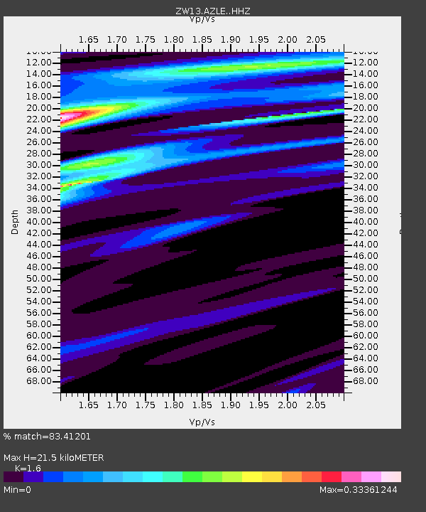
| Estimated Moho Depth: |
21.5 km |
| Estimated Crust Vp/Vs: |
1.60 |
| Assumed Crust Vp: |
6.38 km/s |
| Estimated Crust Vs: |
3.988 km/s |
| Estimated Crust Poisson's Ratio: |
0.18 |
|
| Radial Match: |
83.41201 % |
| Radial Bump: |
311 |
| Transverse Match: |
75.08212 % |
| Transverse Bump: |
393 |
| SOD ConfigId: |
3390531 |
| Insert Time: |
2019-04-13 19:05:57.394 +0000 |
| GWidth: |
2.5 |
| Max Bumps: |
400 |
| Tol: |
0.001 |
|

Signal To Noise
| Channel | StoN | STA | LTA |
| ZW:AZLE: :HHZ:20140902T23:49:24.989994Z | 0.6122864 | 2.2874483E-6 | 3.7359125E-6 |
| ZW:AZLE: :HHN:20140902T23:49:24.989994Z | 0.931729 | 9.1587975E-7 | 9.829894E-7 |
| ZW:AZLE: :HHE:20140902T23:49:24.989994Z | 0.94526345 | 5.773351E-7 | 6.1076634E-7 |
| Arrivals |
| Ps | 2.2 SECOND |
| PpPs | 8.2 SECOND |
| PsPs/PpSs | 10 SECOND |


