You are here: Home > Network List > 7A - Mid-Atlantic Geophysical Integrative Collaboration Stations List
> Station WLFT Gordonsville, Virginia USA > Earthquake Result Viewer
WLFT Gordonsville, Virginia USA - Earthquake Result Viewer
| Earthquake location: |
Iceland |
| Earthquake latitude/longitude: |
64.8/-17.4 |
| Earthquake time(UTC): |
2014/09/03 (246) 03:09:56 GMT |
| Earthquake Depth: |
7.5 km |
| Earthquake Magnitude: |
5.4 MW |
| Earthquake Catalog/Contributor: |
ISC/ISC |
|
| Network: |
7A Mid-Atlantic Geophysical Integrative Collaboration |
| Station: |
WLFT Gordonsville, Virginia USA |
| Lat/Lon: |
38.17 N/78.14 W |
| Elevation: |
110 m |
|
| Distance: |
43.8 deg |
| Az: |
262.948 deg |
| Baz: |
32.618 deg |
| Ray Param: |
0.0722944 |
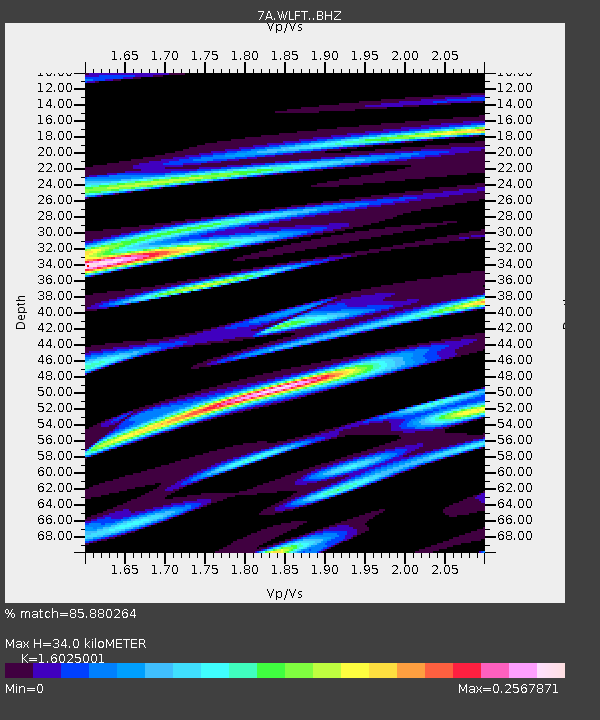
| Estimated Moho Depth: |
34.0 km |
| Estimated Crust Vp/Vs: |
1.60 |
| Assumed Crust Vp: |
6.159 km/s |
| Estimated Crust Vs: |
3.843 km/s |
| Estimated Crust Poisson's Ratio: |
0.18 |
|
| Radial Match: |
85.880264 % |
| Radial Bump: |
319 |
| Transverse Match: |
64.607704 % |
| Transverse Bump: |
400 |
| SOD ConfigId: |
3390531 |
| Insert Time: |
2019-04-13 19:06:10.420 +0000 |
| GWidth: |
2.5 |
| Max Bumps: |
400 |
| Tol: |
0.001 |
|

Signal To Noise
| Channel | StoN | STA | LTA |
| 7A:WLFT: :BHZ:20140903T03:17:32.525006Z | 3.6746187 | 2.0900654E-7 | 5.6878427E-8 |
| 7A:WLFT: :BHN:20140903T03:17:32.525006Z | 2.0842967 | 1.0014012E-7 | 4.804504E-8 |
| 7A:WLFT: :BHE:20140903T03:17:32.525006Z | 1.9988042 | 9.518985E-8 | 4.76234E-8 |
| Arrivals |
| Ps | 3.6 SECOND |
| PpPs | 13 SECOND |
| PsPs/PpSs | 17 SECOND |


