PALK Pallekele, Sri Lanka - Earthquake Result Viewer
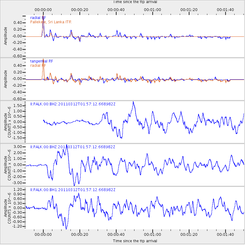
Earthquake location: Off East Coast Of Honshu, Japan
Earthquake latitude/longitude: 37.6/142.6
Earthquake time(UTC): 2011/03/12 (071) 01:47:15 GMT
Earthquake Depth: 20 km
Earthquake Magnitude: 6.2 MB, 6.4 MS, 6.5 MW, 6.5 MW
Earthquake Catalog/Contributor: WHDF/NEIC
Network: II Global Seismograph Network (GSN - IRIS/IDA)
Station: PALK Pallekele, Sri Lanka
Lat/Lon: 7.27 N/80.70 E
Elevation: 460 m
Distance: 63.4 deg
Az: 258.16 deg
Baz: 51.596 deg
Ray Param: 0.05954898
Estimated Moho Depth: 40.25 km
Estimated Crust Vp/Vs: 1.60
Assumed Crust Vp: 6.545 km/s
Estimated Crust Vs: 4.091 km/s
Estimated Crust Poisson's Ratio: 0.18
Radial Match: 91.245865 %
Radial Bump: 308
Transverse Match: 86.10518 %
Transverse Bump: 400
SOD ConfigId: 558545
Insert Time: 2013-09-18 13:10:40.078 +0000
GWidth: 2.5
Max Bumps: 400
Tol: 0.001

Signal To Noise

ChannelStoNSTALTA
II:PALK:00:BHZ:20110312T01:57:12.668982Z9.4747981.1143624E-61.17613304E-7
II:PALK:00:BH1:20110312T01:57:12.668982Z3.22329043.2821148E-71.0182498E-7
II:PALK:00:BH2:20110312T01:57:12.668982Z3.93499024.573449E-71.1622517E-7
Arrivals
Ps3.9 SECOND
PpPs15 SECOND
PsPs/PpSs19 SECOND