You are here: Home > Network List > KZ - Kazakhstan Network Stations List
> Station KUR21 Cross-array, Kurchatov, Kazakstan > Earthquake Result Viewer
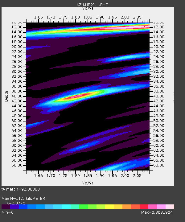
KUR21 Cross-array, Kurchatov, Kazakstan - Earthquake Result Viewer
| Earthquake location: |
Off East Coast Of Honshu, Japan |
| Earthquake latitude/longitude: |
37.6/142.6 |
| Earthquake time(UTC): |
2011/03/12 (071) 01:47:15 GMT |
| Earthquake Depth: |
20 km |
| Earthquake Magnitude: |
6.2 MB, 6.4 MS, 6.5 MW, 6.5 MW |
| Earthquake Catalog/Contributor: |
WHDF/NEIC |
|
| Network: |
KZ Kazakhstan Network |
| Station: |
KUR21 Cross-array, Kurchatov, Kazakstan |
| Lat/Lon: |
50.62 N/78.53 E |
| Elevation: |
200 m |
|
| Distance: |
46.4 deg |
| Az: |
307.731 deg |
| Baz: |
80.495 deg |
| Ray Param: |
0.07062092 |
| Estimated Moho Depth: |
11.5 km |
| Estimated Crust Vp/Vs: |
2.08 |
| Assumed Crust Vp: |
6.552 km/s |
| Estimated Crust Vs: |
3.154 km/s |
| Estimated Crust Poisson's Ratio: |
0.35 |
|
| Radial Match: |
92.38863 % |
| Radial Bump: |
390 |
| Transverse Match: |
93.21945 % |
| Transverse Bump: |
398 |
| SOD ConfigId: |
558545 |
| Insert Time: |
2013-09-18 13:11:43.028 +0000 |
| GWidth: |
2.5 |
| Max Bumps: |
400 |
| Tol: |
0.001 |
|

Signal To Noise
| Channel | StoN | STA | LTA |
| KZ:KUR21: :BHZ:20110312T01:55:09.875006Z | 3.8357215 | 6.772868E-6 | 1.7657351E-6 |
| KZ:KUR21: :BH1:20110312T01:55:09.875006Z | 3.3558164 | 3.842976E-6 | 1.1451688E-6 |
| KZ:KUR21: :BH2:20110312T01:55:09.875006Z | 3.9476523 | 1.0744008E-6 | 2.7216197E-7 |
| Arrivals |
| Ps | 2.0 SECOND |
| PpPs | 5.1 SECOND |
| PsPs/PpSs | 7.1 SECOND |


