You are here: Home > Network List > IU - Global Seismograph Network (GSN - IRIS/USGS) Stations List
> Station PMG Port Moresby, New Guinea > Earthquake Result Viewer
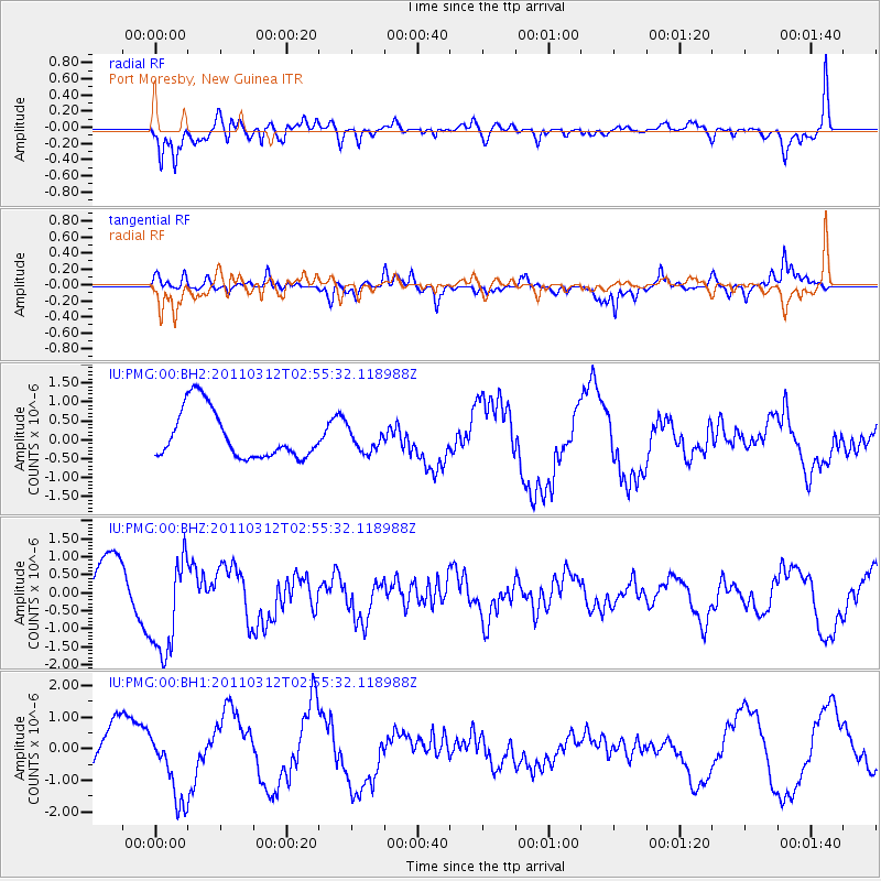
PMG Port Moresby, New Guinea - Earthquake Result Viewer
*The percent match for this event was below the threshold and hence no stack was calculated.
| Earthquake location: |
Off East Coast Of Honshu, Japan |
| Earthquake latitude/longitude: |
37.6/143.6 |
| Earthquake time(UTC): |
2011/03/12 (071) 02:47:33 GMT |
| Earthquake Depth: |
15 km |
| Earthquake Magnitude: |
5.9 MW, 5.7 MB |
| Earthquake Catalog/Contributor: |
NEIC PDE/NEIC PDE-M |
|
| Network: |
IU Global Seismograph Network (GSN - IRIS/USGS) |
| Station: |
PMG Port Moresby, New Guinea |
| Lat/Lon: |
9.40 S/147.16 E |
| Elevation: |
90 m |
|
| Distance: |
46.9 deg |
| Az: |
175.198 deg |
| Baz: |
356.137 deg |
| Ray Param: |
$rayparam |
*The percent match for this event was below the threshold and hence was not used in the summary stack. |
|
| Radial Match: |
63.322197 % |
| Radial Bump: |
400 |
| Transverse Match: |
66.51878 % |
| Transverse Bump: |
382 |
| SOD ConfigId: |
558545 |
| Insert Time: |
2013-09-18 13:12:25.824 +0000 |
| GWidth: |
2.5 |
| Max Bumps: |
400 |
| Tol: |
0.001 |
|
Signal To Noise
| Channel | StoN | STA | LTA |
| IU:PMG:00:BHZ:20110312T02:55:32.118988Z | 2.29332 | 1.4374136E-6 | 6.267829E-7 |
| IU:PMG:00:BH1:20110312T02:55:32.118988Z | 1.1209432 | 1.1919469E-6 | 1.0633429E-6 |
| IU:PMG:00:BH2:20110312T02:55:32.118988Z | 0.4793295 | 3.074003E-7 | 6.4131314E-7 |
| Arrivals |
| Ps | |
| PpPs | |
| PsPs/PpSs | |


