You are here: Home > Network List > IU - Global Seismograph Network (GSN - IRIS/USGS) Stations List
> Station POHA Pohakuloa, Hawaii, USA > Earthquake Result Viewer
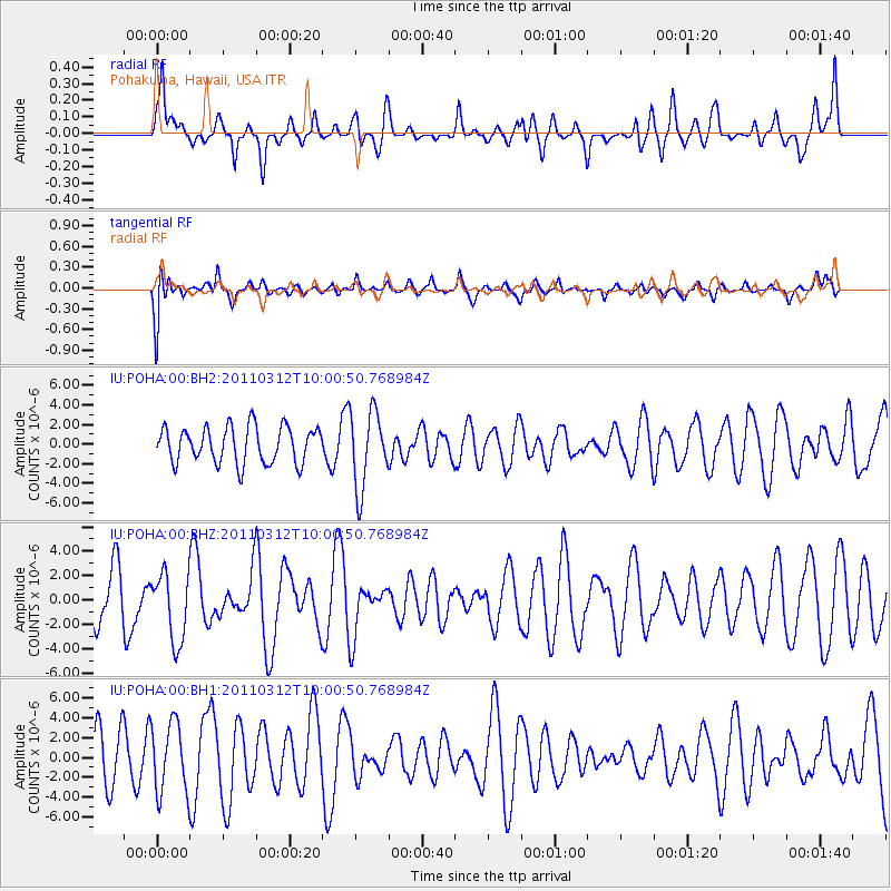
POHA Pohakuloa, Hawaii, USA - Earthquake Result Viewer
*The percent match for this event was below the threshold and hence no stack was calculated.
| Earthquake location: |
New Ireland Region, P.N.G. |
| Earthquake latitude/longitude: |
-3.8/151.5 |
| Earthquake time(UTC): |
2011/03/12 (071) 09:51:35 GMT |
| Earthquake Depth: |
10 km |
| Earthquake Magnitude: |
5.6 MW |
| Earthquake Catalog/Contributor: |
NEIC PDE/NEIC PDE-M |
|
| Network: |
IU Global Seismograph Network (GSN - IRIS/USGS) |
| Station: |
POHA Pohakuloa, Hawaii, USA |
| Lat/Lon: |
19.76 N/155.53 W |
| Elevation: |
1990 m |
|
| Distance: |
57.1 deg |
| Az: |
63.63 deg |
| Baz: |
251.649 deg |
| Ray Param: |
$rayparam |
*The percent match for this event was below the threshold and hence was not used in the summary stack. |
|
| Radial Match: |
62.370167 % |
| Radial Bump: |
400 |
| Transverse Match: |
55.335106 % |
| Transverse Bump: |
400 |
| SOD ConfigId: |
558545 |
| Insert Time: |
2013-09-18 13:18:24.143 +0000 |
| GWidth: |
2.5 |
| Max Bumps: |
400 |
| Tol: |
0.001 |
|
Signal To Noise
| Channel | StoN | STA | LTA |
| IU:POHA:00:BHZ:20110312T10:00:50.768984Z | 1.4439039 | 2.829648E-6 | 1.9597205E-6 |
| IU:POHA:00:BH1:20110312T10:00:50.768984Z | 1.4048527 | 3.5463802E-6 | 2.5243787E-6 |
| IU:POHA:00:BH2:20110312T10:00:50.768984Z | 2.1253033 | 3.9326965E-6 | 1.8504167E-6 |
| Arrivals |
| Ps | |
| PpPs | |
| PsPs/PpSs | |


