You are here: Home > Network List > CN - Canadian National Seismograph Network Stations List
> Station FRB IQALUIT, N.W.T. > Earthquake Result Viewer
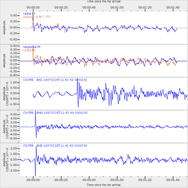
FRB IQALUIT, N.W.T. - Earthquake Result Viewer
*The percent match for this event was below the threshold and hence no stack was calculated.
| Earthquake location: |
Kuril Islands |
| Earthquake latitude/longitude: |
43.9/147.9 |
| Earthquake time(UTC): |
1997/02/28 (059) 11:32:18 GMT |
| Earthquake Depth: |
33 km |
| Earthquake Magnitude: |
6.1 MB, 5.5 MS, 5.9 UNKNOWN, 5.7 MW |
| Earthquake Catalog/Contributor: |
WHDF/NEIC |
|
| Network: |
CN Canadian National Seismograph Network |
| Station: |
FRB IQALUIT, N.W.T. |
| Lat/Lon: |
63.75 N/68.55 W |
| Elevation: |
18 m |
|
| Distance: |
68.9 deg |
| Az: |
16.445 deg |
| Baz: |
332.614 deg |
| Ray Param: |
$rayparam |
*The percent match for this event was below the threshold and hence was not used in the summary stack. |
|
| Radial Match: |
69.47147 % |
| Radial Bump: |
400 |
| Transverse Match: |
65.23178 % |
| Transverse Bump: |
400 |
| SOD ConfigId: |
4480 |
| Insert Time: |
2010-02-27 05:52:15.984 +0000 |
| GWidth: |
2.5 |
| Max Bumps: |
400 |
| Tol: |
0.001 |
|
Signal To Noise
| Channel | StoN | STA | LTA |
| CN:FRB: :BHN:19970228T11:42:49.300024Z | 10.162103 | 2.206487E-6 | 2.1712897E-7 |
| CN:FRB: :BHE:19970228T11:42:49.300024Z | 5.7253833 | 8.9063883E-7 | 1.5555969E-7 |
| CN:FRB: :BHZ:19970228T11:42:49.300024Z | 3.388551 | 5.3822055E-7 | 1.5883501E-7 |
| Arrivals |
| Ps | |
| PpPs | |
| PsPs/PpSs | |


