You are here: Home > Network List > CN - Canadian National Seismograph Network Stations List
> Station FRB IQALUIT, N.W.T. > Earthquake Result Viewer
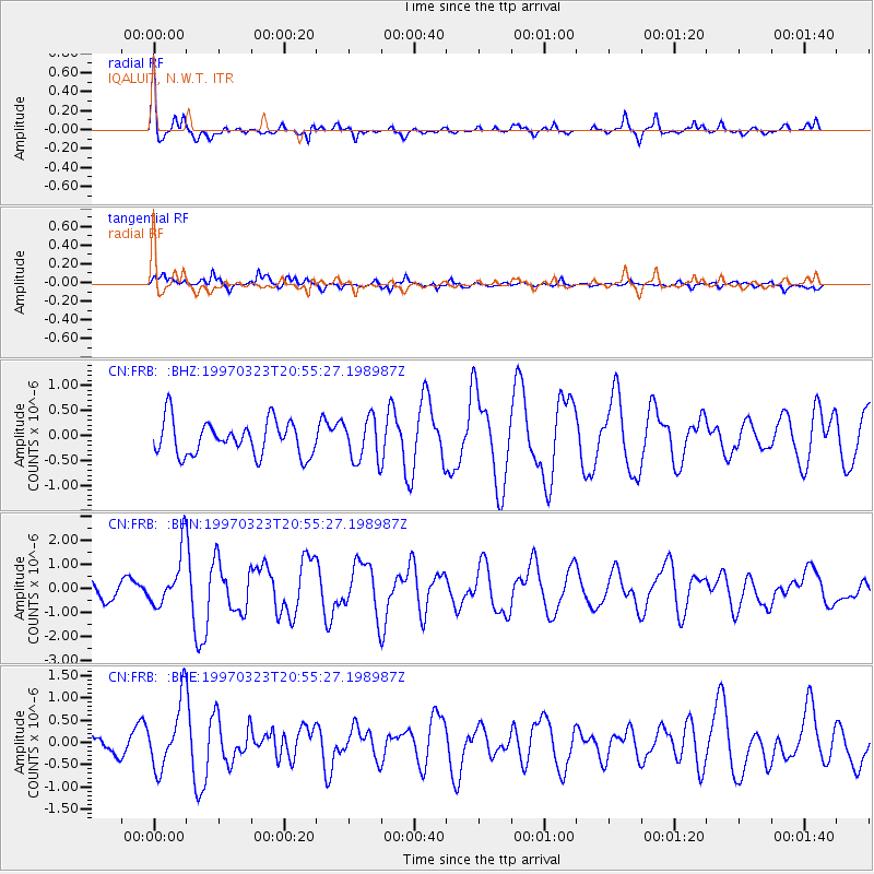
FRB IQALUIT, N.W.T. - Earthquake Result Viewer
*The percent match for this event was below the threshold and hence no stack was calculated.
| Earthquake location: |
Northern Mid-Atlantic Ridge |
| Earthquake latitude/longitude: |
31.0/-41.5 |
| Earthquake time(UTC): |
1997/03/23 (082) 20:48:48 GMT |
| Earthquake Depth: |
10 km |
| Earthquake Magnitude: |
5.9 MS, 5.4 MB, 5.9 UNKNOWN, 5.9 MW |
| Earthquake Catalog/Contributor: |
WHDF/NEIC |
|
| Network: |
CN Canadian National Seismograph Network |
| Station: |
FRB IQALUIT, N.W.T. |
| Lat/Lon: |
63.75 N/68.55 W |
| Elevation: |
18 m |
|
| Distance: |
37.0 deg |
| Az: |
340.372 deg |
| Baz: |
139.559 deg |
| Ray Param: |
$rayparam |
*The percent match for this event was below the threshold and hence was not used in the summary stack. |
|
| Radial Match: |
74.548615 % |
| Radial Bump: |
353 |
| Transverse Match: |
73.73765 % |
| Transverse Bump: |
391 |
| SOD ConfigId: |
4480 |
| Insert Time: |
2010-02-27 05:52:18.361 +0000 |
| GWidth: |
2.5 |
| Max Bumps: |
400 |
| Tol: |
0.001 |
|
Signal To Noise
| Channel | StoN | STA | LTA |
| CN:FRB: :BHN:19970323T20:55:27.198987Z | 4.149581 | 1.1331927E-6 | 2.7308604E-7 |
| CN:FRB: :BHE:19970323T20:55:27.198987Z | 2.7313464 | 7.425924E-7 | 2.718778E-7 |
| CN:FRB: :BHZ:19970323T20:55:27.198987Z | 1.2471553 | 4.2822654E-7 | 3.4336264E-7 |
| Arrivals |
| Ps | |
| PpPs | |
| PsPs/PpSs | |


