You are here: Home > Network List > IU - Global Seismograph Network (GSN - IRIS/USGS) Stations List
> Station PMG Port Moresby, New Guinea > Earthquake Result Viewer
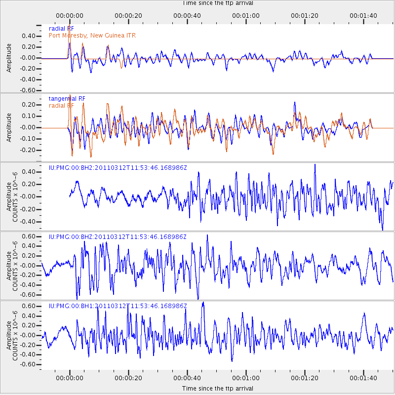
PMG Port Moresby, New Guinea - Earthquake Result Viewer
*The percent match for this event was below the threshold and hence no stack was calculated.
| Earthquake location: |
Near East Coast Of Honshu, Japan |
| Earthquake latitude/longitude: |
35.7/141.7 |
| Earthquake time(UTC): |
2011/03/12 (071) 11:45:59 GMT |
| Earthquake Depth: |
10 km |
| Earthquake Magnitude: |
5.6 MB |
| Earthquake Catalog/Contributor: |
WHDF/NEIC |
|
| Network: |
IU Global Seismograph Network (GSN - IRIS/USGS) |
| Station: |
PMG Port Moresby, New Guinea |
| Lat/Lon: |
9.40 S/147.16 E |
| Elevation: |
90 m |
|
| Distance: |
45.2 deg |
| Az: |
172.37 deg |
| Baz: |
353.716 deg |
| Ray Param: |
$rayparam |
*The percent match for this event was below the threshold and hence was not used in the summary stack. |
|
| Radial Match: |
56.854366 % |
| Radial Bump: |
400 |
| Transverse Match: |
54.908543 % |
| Transverse Bump: |
400 |
| SOD ConfigId: |
558545 |
| Insert Time: |
2013-09-18 13:21:44.743 +0000 |
| GWidth: |
2.5 |
| Max Bumps: |
400 |
| Tol: |
0.001 |
|
Signal To Noise
| Channel | StoN | STA | LTA |
| IU:PMG:00:BHZ:20110312T11:53:46.168986Z | 1.7802017 | 2.8725577E-7 | 1.6136136E-7 |
| IU:PMG:00:BH1:20110312T11:53:46.168986Z | 1.534581 | 1.519633E-7 | 9.902593E-8 |
| IU:PMG:00:BH2:20110312T11:53:46.168986Z | 0.8633821 | 8.014652E-8 | 9.2828564E-8 |
| Arrivals |
| Ps | |
| PpPs | |
| PsPs/PpSs | |


