You are here: Home > Network List > IU - Global Seismograph Network (GSN - IRIS/USGS) Stations List
> Station HNR Honiara, Solomon Islands > Earthquake Result Viewer
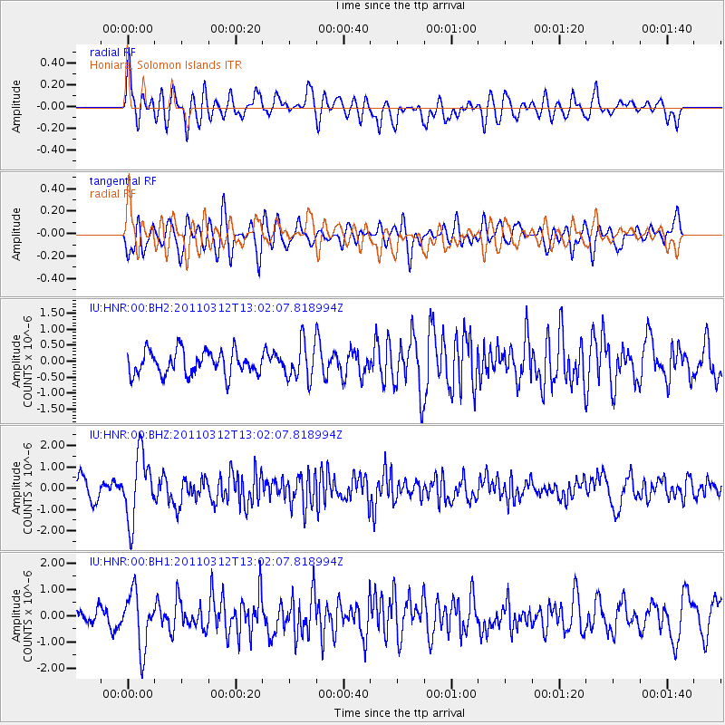
HNR Honiara, Solomon Islands - Earthquake Result Viewer
*The percent match for this event was below the threshold and hence no stack was calculated.
| Earthquake location: |
Off East Coast Of Honshu, Japan |
| Earthquake latitude/longitude: |
37.7/143.5 |
| Earthquake time(UTC): |
2011/03/12 (071) 12:53:52 GMT |
| Earthquake Depth: |
34 km |
| Earthquake Magnitude: |
5.9 MW, 5.8 MB, 5.8 MS |
| Earthquake Catalog/Contributor: |
NEIC PDE/NEIC PDE-M |
|
| Network: |
IU Global Seismograph Network (GSN - IRIS/USGS) |
| Station: |
HNR Honiara, Solomon Islands |
| Lat/Lon: |
9.44 S/159.95 E |
| Elevation: |
100 m |
|
| Distance: |
49.4 deg |
| Az: |
158.415 deg |
| Baz: |
342.805 deg |
| Ray Param: |
$rayparam |
*The percent match for this event was below the threshold and hence was not used in the summary stack. |
|
| Radial Match: |
69.02909 % |
| Radial Bump: |
400 |
| Transverse Match: |
66.11875 % |
| Transverse Bump: |
400 |
| SOD ConfigId: |
558545 |
| Insert Time: |
2013-09-18 13:22:51.698 +0000 |
| GWidth: |
2.5 |
| Max Bumps: |
400 |
| Tol: |
0.001 |
|
Signal To Noise
| Channel | StoN | STA | LTA |
| IU:HNR:00:BHZ:20110312T13:02:07.818994Z | 2.6978579 | 1.5648574E-6 | 5.80037E-7 |
| IU:HNR:00:BH1:20110312T13:02:07.818994Z | 2.5963511 | 1.067802E-6 | 4.112703E-7 |
| IU:HNR:00:BH2:20110312T13:02:07.818994Z | 1.5938007 | 5.941483E-7 | 3.7278707E-7 |
| Arrivals |
| Ps | |
| PpPs | |
| PsPs/PpSs | |


