You are here: Home > Network List > IU - Global Seismograph Network (GSN - IRIS/USGS) Stations List
> Station PMG Port Moresby, New Guinea > Earthquake Result Viewer
PMG Port Moresby, New Guinea - Earthquake Result Viewer
| Earthquake location: |
Off East Coast Of Honshu, Japan |
| Earthquake latitude/longitude: |
37.7/143.5 |
| Earthquake time(UTC): |
2011/03/12 (071) 12:53:52 GMT |
| Earthquake Depth: |
34 km |
| Earthquake Magnitude: |
5.9 MW, 5.8 MB, 5.8 MS |
| Earthquake Catalog/Contributor: |
NEIC PDE/NEIC PDE-M |
|
| Network: |
IU Global Seismograph Network (GSN - IRIS/USGS) |
| Station: |
PMG Port Moresby, New Guinea |
| Lat/Lon: |
9.40 S/147.16 E |
| Elevation: |
90 m |
|
| Distance: |
47.0 deg |
| Az: |
175.069 deg |
| Baz: |
356.04 deg |
| Ray Param: |
0.07020074 |
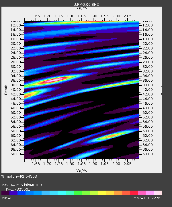
| Estimated Moho Depth: |
35.5 km |
| Estimated Crust Vp/Vs: |
1.73 |
| Assumed Crust Vp: |
6.122 km/s |
| Estimated Crust Vs: |
3.534 km/s |
| Estimated Crust Poisson's Ratio: |
0.25 |
|
| Radial Match: |
92.04503 % |
| Radial Bump: |
400 |
| Transverse Match: |
75.06314 % |
| Transverse Bump: |
400 |
| SOD ConfigId: |
558545 |
| Insert Time: |
2013-09-18 13:23:01.006 +0000 |
| GWidth: |
2.5 |
| Max Bumps: |
400 |
| Tol: |
0.001 |
|

Signal To Noise
| Channel | StoN | STA | LTA |
| IU:PMG:00:BHZ:20110312T13:01:49.568994Z | 15.399885 | 1.7660639E-6 | 1.14680326E-7 |
| IU:PMG:00:BH1:20110312T13:01:49.568994Z | 5.6398892 | 7.202628E-7 | 1.2770867E-7 |
| IU:PMG:00:BH2:20110312T13:01:49.568994Z | 2.6817424 | 2.4668762E-7 | 9.1987815E-8 |
| Arrivals |
| Ps | 4.5 SECOND |
| PpPs | 15 SECOND |
| PsPs/PpSs | 19 SECOND |


