You are here: Home > Network List > IU - Global Seismograph Network (GSN - IRIS/USGS) Stations List
> Station HNR Honiara, Solomon Islands > Earthquake Result Viewer
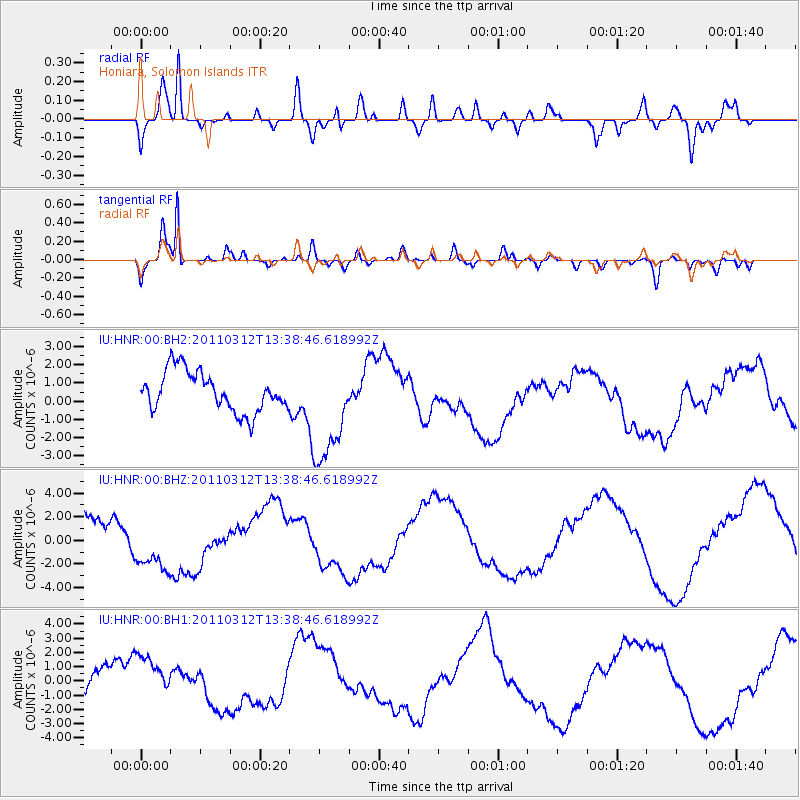
HNR Honiara, Solomon Islands - Earthquake Result Viewer
*The percent match for this event was below the threshold and hence no stack was calculated.
| Earthquake location: |
Gulf Of California |
| Earthquake latitude/longitude: |
25.2/-109.8 |
| Earthquake time(UTC): |
2011/03/12 (071) 13:25:59 GMT |
| Earthquake Depth: |
13 km |
| Earthquake Magnitude: |
5.5 MW, 5.2 MS, 5.3 MB |
| Earthquake Catalog/Contributor: |
WHDF/NEIC |
|
| Network: |
IU Global Seismograph Network (GSN - IRIS/USGS) |
| Station: |
HNR Honiara, Solomon Islands |
| Lat/Lon: |
9.44 S/159.95 E |
| Elevation: |
100 m |
|
| Distance: |
94.2 deg |
| Az: |
261.589 deg |
| Baz: |
65.264 deg |
| Ray Param: |
$rayparam |
*The percent match for this event was below the threshold and hence was not used in the summary stack. |
|
| Radial Match: |
79.04324 % |
| Radial Bump: |
400 |
| Transverse Match: |
89.70499 % |
| Transverse Bump: |
400 |
| SOD ConfigId: |
558545 |
| Insert Time: |
2013-09-18 13:25:18.816 +0000 |
| GWidth: |
2.5 |
| Max Bumps: |
400 |
| Tol: |
0.001 |
|
Signal To Noise
| Channel | StoN | STA | LTA |
| IU:HNR:00:BHZ:20110312T13:38:46.618992Z | 1.3791692 | 2.2129009E-6 | 1.6045173E-6 |
| IU:HNR:00:BH1:20110312T13:38:46.618992Z | 2.0269225 | 1.841433E-6 | 9.084872E-7 |
| IU:HNR:00:BH2:20110312T13:38:46.618992Z | 2.709078 | 2.958891E-6 | 1.0922133E-6 |
| Arrivals |
| Ps | |
| PpPs | |
| PsPs/PpSs | |


