You are here: Home > Network List > CN - Canadian National Seismograph Network Stations List
> Station FRB IQALUIT, N.W.T. > Earthquake Result Viewer
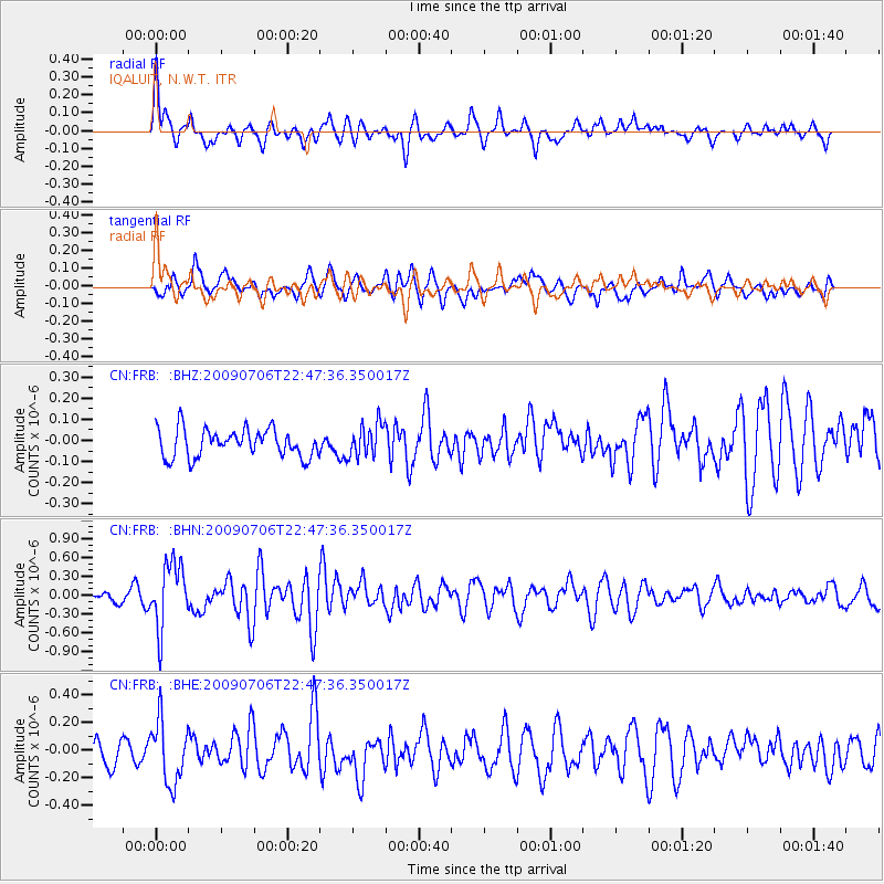
FRB IQALUIT, N.W.T. - Earthquake Result Viewer
*The percent match for this event was below the threshold and hence no stack was calculated.
| Earthquake location: |
Southeast Of Ryukyu Islands |
| Earthquake latitude/longitude: |
24.9/128.0 |
| Earthquake time(UTC): |
2009/07/06 (187) 22:35:05 GMT |
| Earthquake Depth: |
10 km |
| Earthquake Magnitude: |
6.1 MB, 5.3 MS, 5.7 MW, 5.7 MW |
| Earthquake Catalog/Contributor: |
WHDF/NEIC |
|
| Network: |
CN Canadian National Seismograph Network |
| Station: |
FRB IQALUIT, N.W.T. |
| Lat/Lon: |
63.75 N/68.55 W |
| Elevation: |
18 m |
|
| Distance: |
90.7 deg |
| Az: |
7.289 deg |
| Baz: |
344.983 deg |
| Ray Param: |
$rayparam |
*The percent match for this event was below the threshold and hence was not used in the summary stack. |
|
| Radial Match: |
63.689365 % |
| Radial Bump: |
400 |
| Transverse Match: |
61.240883 % |
| Transverse Bump: |
400 |
| SOD ConfigId: |
2648 |
| Insert Time: |
2010-02-27 05:52:29.768 +0000 |
| GWidth: |
2.5 |
| Max Bumps: |
400 |
| Tol: |
0.001 |
|
Signal To Noise
| Channel | StoN | STA | LTA |
| CN:FRB: :BHN:20090706T22:47:36.350017Z | 5.2362947 | 5.130768E-7 | 9.798471E-8 |
| CN:FRB: :BHE:20090706T22:47:36.350017Z | 2.4360805 | 2.2685683E-7 | 9.31237E-8 |
| CN:FRB: :BHZ:20090706T22:47:36.350017Z | 1.1705987 | 7.747437E-8 | 6.618354E-8 |
| Arrivals |
| Ps | |
| PpPs | |
| PsPs/PpSs | |


