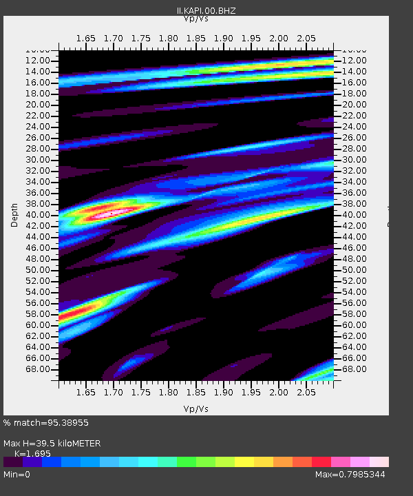
KAPI Kappang, Sulawesi, Indonesia - Earthquake Result Viewer

Earthquake location: Near East Coast Of Honshu, Japan
Earthquake latitude/longitude: 35.7/141.6
Earthquake time(UTC): 2011/03/13 (072) 01:26:04 GMT
Earthquake Depth: 8.0 km
Earthquake Magnitude: 6.1 MW, 5.9 MB, 6.1 MW, 6.2 MS
Earthquake Catalog/Contributor: NEIC PDE/NEIC PDE-M
Network: II Global Seismograph Network (GSN - IRIS/IDA)
Station: KAPI Kappang, Sulawesi, Indonesia
Lat/Lon: 5.01 S/119.75 E
Elevation: 300 m
Distance: 45.4 deg
Az: 211.415 deg
Baz: 25.197 deg
Ray Param: 0.07128674
Estimated Moho Depth: 39.5 km
Estimated Crust Vp/Vs: 1.70
Assumed Crust Vp: 6.343 km/s
Estimated Crust Vs: 3.742 km/s
Estimated Crust Poisson's Ratio: 0.23
Radial Match: 95.38955 %
Radial Bump: 400
Transverse Match: 95.420074 %
Transverse Bump: 400
SOD ConfigId: 558545
Insert Time: 2013-09-18 13:36:52.695 +0000
GWidth: 2.5
Max Bumps: 400
Tol: 0.001

Signal To Noise

ChannelStoNSTALTA
II:KAPI:00:BHZ:20110313T01:33:52.569Z46.2444763.908852E-68.452581E-8
II:KAPI:00:BH1:20110313T01:33:52.569Z27.6704651.8652752E-66.7410326E-8
II:KAPI:00:BH2:20110313T01:33:52.569Z17.0716277.822393E-74.5821018E-8
Arrivals
Ps4.6 SECOND
PpPs16 SECOND
PsPs/PpSs20 SECOND