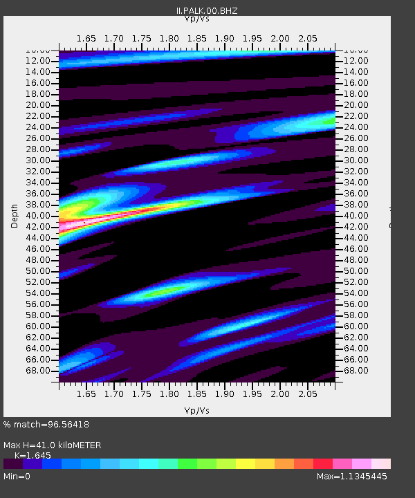
PALK Pallekele, Sri Lanka - Earthquake Result Viewer
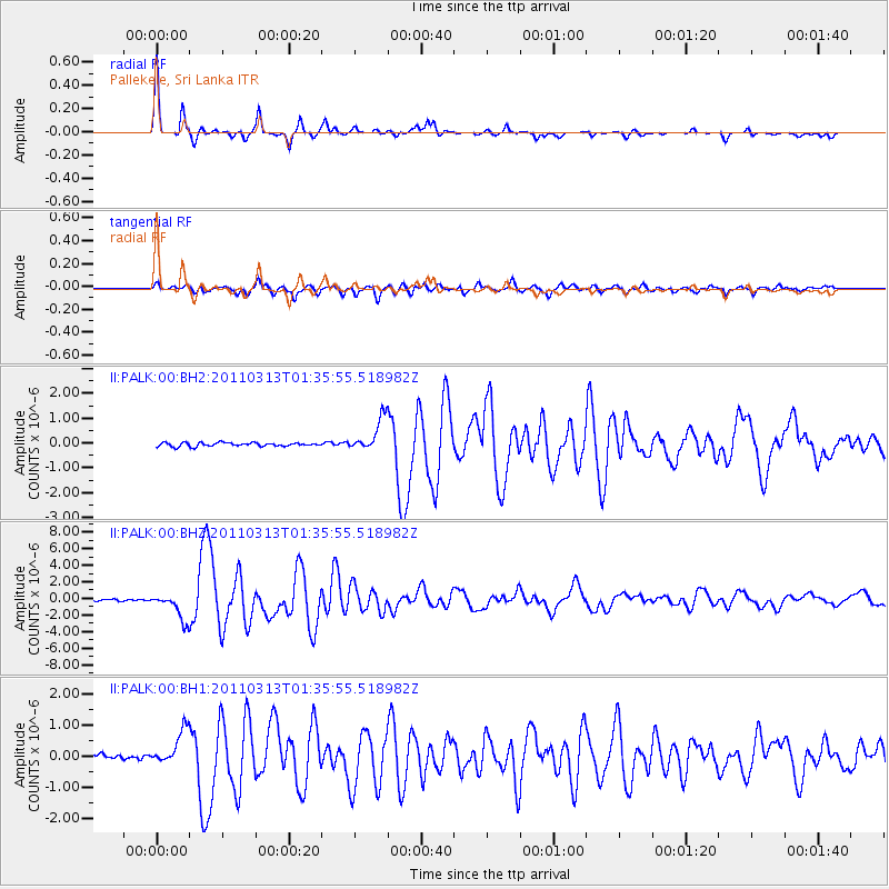
Earthquake location: Near East Coast Of Honshu, Japan
Earthquake latitude/longitude: 35.7/141.6
Earthquake time(UTC): 2011/03/13 (072) 01:26:04 GMT
Earthquake Depth: 8.0 km
Earthquake Magnitude: 6.1 MW, 5.9 MB, 6.1 MW, 6.2 MS
Earthquake Catalog/Contributor: NEIC PDE/NEIC PDE-M
Network: II Global Seismograph Network (GSN - IRIS/IDA)
Station: PALK Pallekele, Sri Lanka
Lat/Lon: 7.27 N/80.70 E
Elevation: 460 m
Distance: 62.3 deg
Az: 258.411 deg
Baz: 53.465 deg
Ray Param: 0.060340125
Estimated Moho Depth: 41.0 km
Estimated Crust Vp/Vs: 1.64
Assumed Crust Vp: 6.545 km/s
Estimated Crust Vs: 3.979 km/s
Estimated Crust Poisson's Ratio: 0.21
Radial Match: 96.56418 %
Radial Bump: 289
Transverse Match: 90.43443 %
Transverse Bump: 400
SOD ConfigId: 558545
Insert Time: 2013-09-18 13:36:58.537 +0000
GWidth: 2.5
Max Bumps: 400
Tol: 0.001

Signal To Noise

ChannelStoNSTALTA
II:PALK:00:BHZ:20110313T01:35:55.518982Z16.0149731.6380525E-61.0228256E-7
II:PALK:00:BH1:20110313T01:35:55.518982Z7.51945925.5359595E-77.362178E-8
II:PALK:00:BH2:20110313T01:35:55.518982Z8.9980856.609417E-77.345359E-8
Arrivals
Ps4.2 SECOND
PpPs16 SECOND
PsPs/PpSs20 SECOND