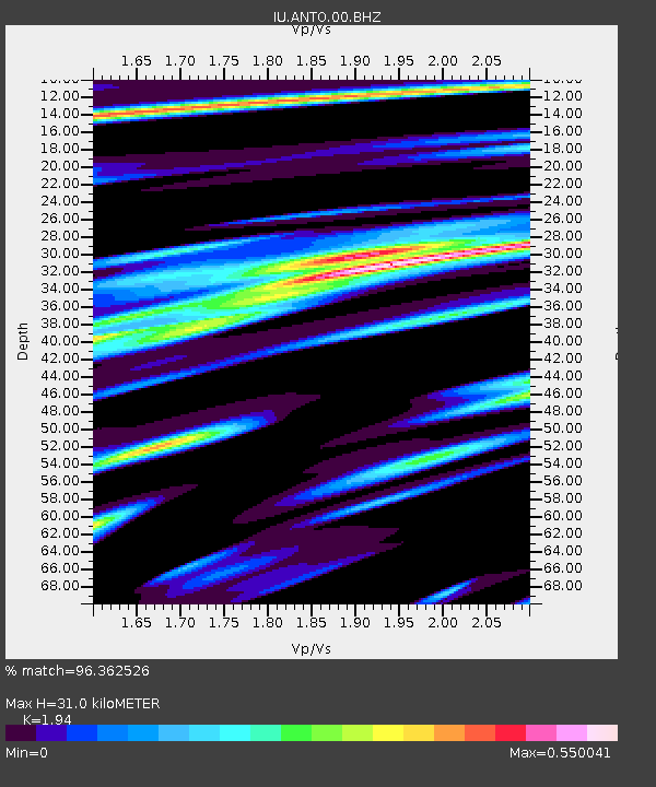
ANTO Ankara, Turkey - Earthquake Result Viewer
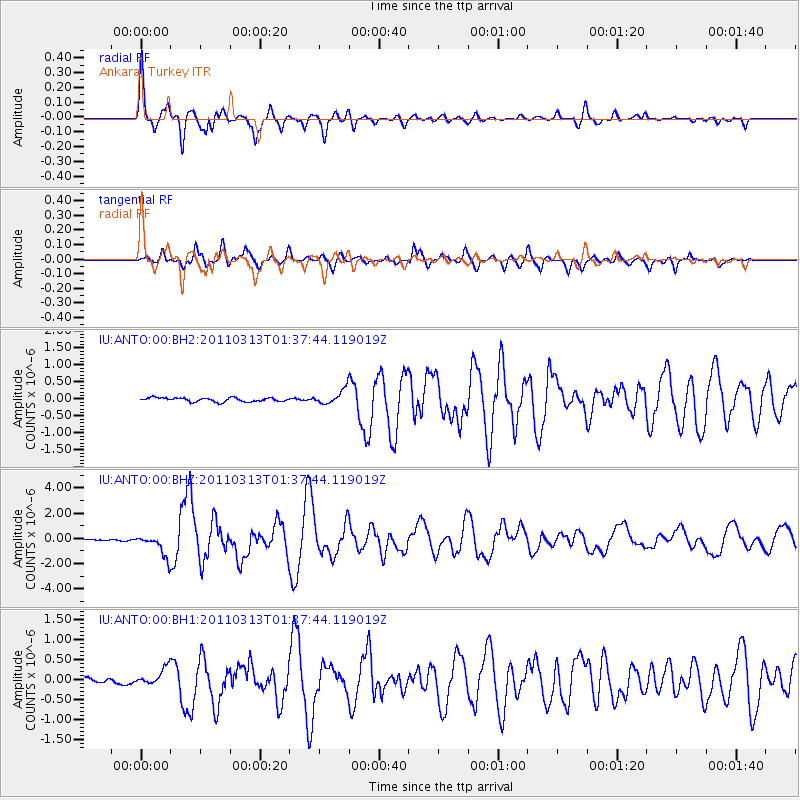
Earthquake location: Near East Coast Of Honshu, Japan
Earthquake latitude/longitude: 35.7/141.6
Earthquake time(UTC): 2011/03/13 (072) 01:26:04 GMT
Earthquake Depth: 8.0 km
Earthquake Magnitude: 6.1 MW, 5.9 MB, 6.1 MW, 6.2 MS
Earthquake Catalog/Contributor: NEIC PDE/NEIC PDE-M
Network: IU Global Seismograph Network (GSN - IRIS/USGS)
Station: ANTO Ankara, Turkey
Lat/Lon: 39.87 N/32.79 E
Elevation: 1090 m
Distance: 80.3 deg
Az: 312.354 deg
Baz: 51.381 deg
Ray Param: 0.048389383
Estimated Moho Depth: 31.0 km
Estimated Crust Vp/Vs: 1.94
Assumed Crust Vp: 6.159 km/s
Estimated Crust Vs: 3.175 km/s
Estimated Crust Poisson's Ratio: 0.32
Radial Match: 96.362526 %
Radial Bump: 400
Transverse Match: 87.88691 %
Transverse Bump: 400
SOD ConfigId: 558545
Insert Time: 2013-09-18 13:37:16.548 +0000
GWidth: 2.5
Max Bumps: 400
Tol: 0.001

Signal To Noise

ChannelStoNSTALTA
IU:ANTO:00:BHZ:20110313T01:37:44.119019Z21.806469.1101253E-74.1777184E-8
IU:ANTO:00:BH1:20110313T01:37:44.119019Z2.79972122.2177196E-77.921216E-8
IU:ANTO:00:BH2:20110313T01:37:44.119019Z3.765752.152784E-75.7167473E-8
Arrivals
Ps4.8 SECOND
PpPs14 SECOND
PsPs/PpSs19 SECOND