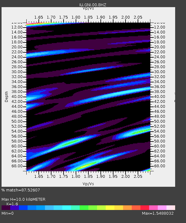
GNI Garni, Armenia - Earthquake Result Viewer
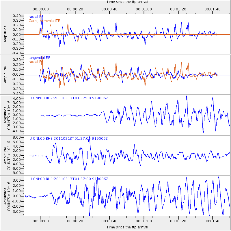
Earthquake location: Near East Coast Of Honshu, Japan
Earthquake latitude/longitude: 35.7/141.6
Earthquake time(UTC): 2011/03/13 (072) 01:26:04 GMT
Earthquake Depth: 8.0 km
Earthquake Magnitude: 6.1 MW, 5.9 MB, 6.1 MW, 6.2 MS
Earthquake Catalog/Contributor: NEIC PDE/NEIC PDE-M
Network: IU Global Seismograph Network (GSN - IRIS/USGS)
Station: GNI Garni, Armenia
Lat/Lon: 40.15 N/44.74 E
Elevation: 1609 m
Distance: 72.6 deg
Az: 307.127 deg
Baz: 57.821 deg
Ray Param: 0.053533677
Estimated Moho Depth: 10.0 km
Estimated Crust Vp/Vs: 1.60
Assumed Crust Vp: 6.291 km/s
Estimated Crust Vs: 3.932 km/s
Estimated Crust Poisson's Ratio: 0.18
Radial Match: 87.52607 %
Radial Bump: 400
Transverse Match: 87.515045 %
Transverse Bump: 400
SOD ConfigId: 558545
Insert Time: 2013-09-18 13:37:32.880 +0000
GWidth: 2.5
Max Bumps: 400
Tol: 0.001

Signal To Noise

ChannelStoNSTALTA
IU:GNI:00:BHZ:20110313T01:37:00.919006Z8.477777.9156695E-79.3369714E-8
IU:GNI:00:BH1:20110313T01:37:00.919006Z1.95074822.2327472E-71.1445594E-7
IU:GNI:00:BH2:20110313T01:37:00.919006Z1.34874841.6151937E-71.19755E-7
Arrivals
Ps1.0 SECOND
PpPs4.0 SECOND
PsPs/PpSs5.0 SECOND