You are here: Home > Network List > II - Global Seismograph Network (GSN - IRIS/IDA) Stations List
> Station WRAB Tennant Creek, NT, Australia > Earthquake Result Viewer
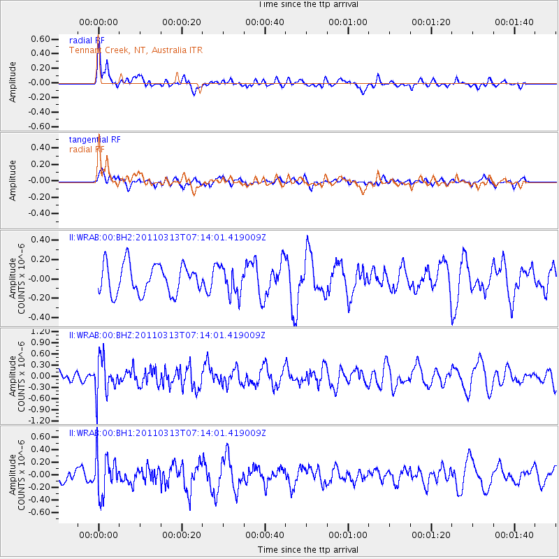
WRAB Tennant Creek, NT, Australia - Earthquake Result Viewer
*The percent match for this event was below the threshold and hence no stack was calculated.
| Earthquake location: |
Off East Coast Of Honshu, Japan |
| Earthquake latitude/longitude: |
38.3/144.0 |
| Earthquake time(UTC): |
2011/03/13 (072) 07:04:38 GMT |
| Earthquake Depth: |
35 km |
| Earthquake Magnitude: |
5.7 MB, 5.3 MW |
| Earthquake Catalog/Contributor: |
WHDF/NEIC |
|
| Network: |
II Global Seismograph Network (GSN - IRIS/IDA) |
| Station: |
WRAB Tennant Creek, NT, Australia |
| Lat/Lon: |
19.93 S/134.36 E |
| Elevation: |
366 m |
|
| Distance: |
58.7 deg |
| Az: |
190.651 deg |
| Baz: |
8.889 deg |
| Ray Param: |
$rayparam |
*The percent match for this event was below the threshold and hence was not used in the summary stack. |
|
| Radial Match: |
71.78455 % |
| Radial Bump: |
400 |
| Transverse Match: |
27.875586 % |
| Transverse Bump: |
377 |
| SOD ConfigId: |
558545 |
| Insert Time: |
2013-09-18 13:41:16.002 +0000 |
| GWidth: |
2.5 |
| Max Bumps: |
400 |
| Tol: |
0.001 |
|
Signal To Noise
| Channel | StoN | STA | LTA |
| II:WRAB:00:BHZ:20110313T07:14:01.419009Z | 4.3909993 | 4.842048E-7 | 1.1027211E-7 |
| II:WRAB:00:BH1:20110313T07:14:01.419009Z | 2.6507273 | 3.1286362E-7 | 1.18029355E-7 |
| II:WRAB:00:BH2:20110313T07:14:01.419009Z | 0.94224143 | 1.4169896E-7 | 1.5038499E-7 |
| Arrivals |
| Ps | |
| PpPs | |
| PsPs/PpSs | |


