You are here: Home > Network List > II - Global Seismograph Network (GSN - IRIS/IDA) Stations List
> Station WRAB Tennant Creek, NT, Australia > Earthquake Result Viewer
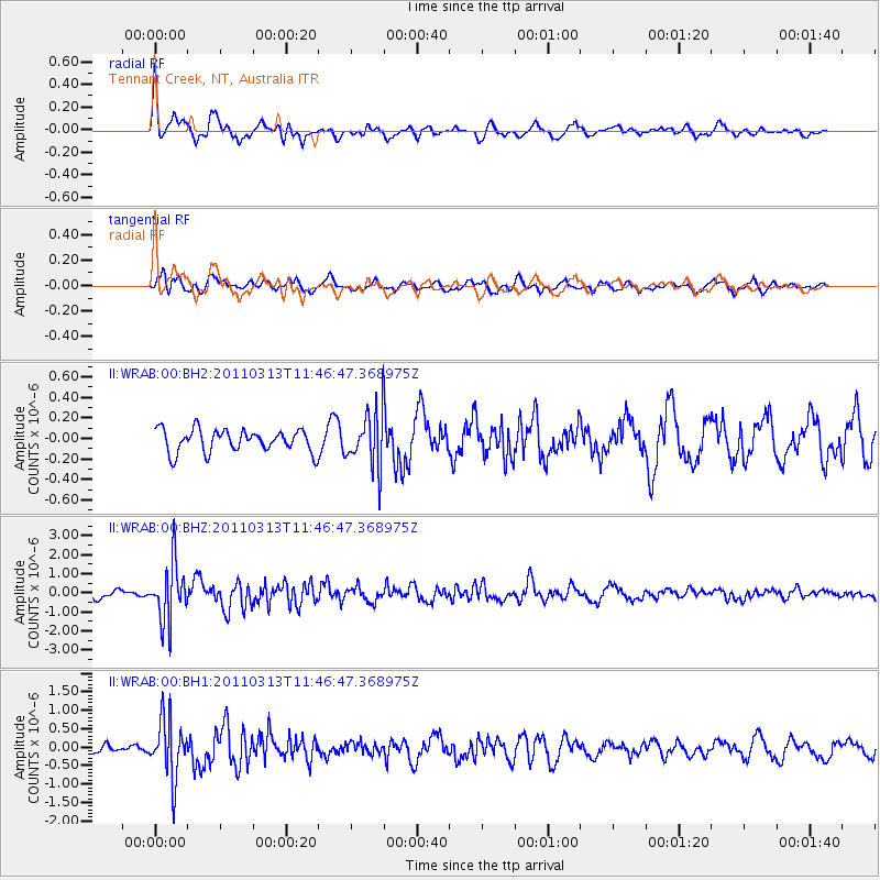
WRAB Tennant Creek, NT, Australia - Earthquake Result Viewer
*The percent match for this event was below the threshold and hence no stack was calculated.
| Earthquake location: |
Off East Coast Of Honshu, Japan |
| Earthquake latitude/longitude: |
37.3/142.4 |
| Earthquake time(UTC): |
2011/03/13 (072) 11:37:30 GMT |
| Earthquake Depth: |
17 km |
| Earthquake Magnitude: |
5.7 MW, 5.6 MS, 5.7 MB, 5.8 MW |
| Earthquake Catalog/Contributor: |
NEIC PDE/NEIC PDE-M |
|
| Network: |
II Global Seismograph Network (GSN - IRIS/IDA) |
| Station: |
WRAB Tennant Creek, NT, Australia |
| Lat/Lon: |
19.93 S/134.36 E |
| Elevation: |
366 m |
|
| Distance: |
57.5 deg |
| Az: |
188.972 deg |
| Baz: |
7.591 deg |
| Ray Param: |
$rayparam |
*The percent match for this event was below the threshold and hence was not used in the summary stack. |
|
| Radial Match: |
72.058624 % |
| Radial Bump: |
400 |
| Transverse Match: |
52.913002 % |
| Transverse Bump: |
400 |
| SOD ConfigId: |
558545 |
| Insert Time: |
2013-09-18 13:45:59.473 +0000 |
| GWidth: |
2.5 |
| Max Bumps: |
400 |
| Tol: |
0.001 |
|
Signal To Noise
| Channel | StoN | STA | LTA |
| II:WRAB:00:BHZ:20110313T11:46:47.368975Z | 7.988832 | 1.5148513E-6 | 1.8962113E-7 |
| II:WRAB:00:BH1:20110313T11:46:47.368975Z | 8.006416 | 7.95074E-7 | 9.930461E-8 |
| II:WRAB:00:BH2:20110313T11:46:47.368975Z | 2.4497929 | 2.6838512E-7 | 1.09554215E-7 |
| Arrivals |
| Ps | |
| PpPs | |
| PsPs/PpSs | |


