You are here: Home > Network List > IU - Global Seismograph Network (GSN - IRIS/USGS) Stations List
> Station RSSD Black Hills, South Dakota, USA > Earthquake Result Viewer
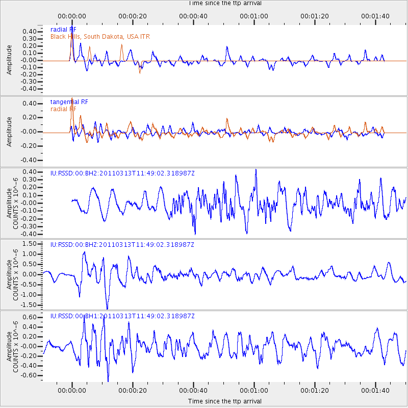
RSSD Black Hills, South Dakota, USA - Earthquake Result Viewer
*The percent match for this event was below the threshold and hence no stack was calculated.
| Earthquake location: |
Off East Coast Of Honshu, Japan |
| Earthquake latitude/longitude: |
37.3/142.4 |
| Earthquake time(UTC): |
2011/03/13 (072) 11:37:30 GMT |
| Earthquake Depth: |
17 km |
| Earthquake Magnitude: |
5.7 MW, 5.6 MS, 5.7 MB, 5.8 MW |
| Earthquake Catalog/Contributor: |
NEIC PDE/NEIC PDE-M |
|
| Network: |
IU Global Seismograph Network (GSN - IRIS/USGS) |
| Station: |
RSSD Black Hills, South Dakota, USA |
| Lat/Lon: |
44.12 N/104.04 W |
| Elevation: |
2090 m |
|
| Distance: |
79.1 deg |
| Az: |
42.246 deg |
| Baz: |
311.933 deg |
| Ray Param: |
$rayparam |
*The percent match for this event was below the threshold and hence was not used in the summary stack. |
|
| Radial Match: |
60.86058 % |
| Radial Bump: |
304 |
| Transverse Match: |
60.37877 % |
| Transverse Bump: |
400 |
| SOD ConfigId: |
558545 |
| Insert Time: |
2013-09-18 13:46:37.021 +0000 |
| GWidth: |
2.5 |
| Max Bumps: |
400 |
| Tol: |
0.001 |
|
Signal To Noise
| Channel | StoN | STA | LTA |
| IU:RSSD:00:BHZ:20110313T11:49:02.318987Z | 4.1122866 | 5.8484017E-7 | 1.4221776E-7 |
| IU:RSSD:00:BH1:20110313T11:49:02.318987Z | 1.4669383 | 2.4815935E-7 | 1.6916823E-7 |
| IU:RSSD:00:BH2:20110313T11:49:02.318987Z | 1.2445474 | 1.2943467E-7 | 1.0400141E-7 |
| Arrivals |
| Ps | |
| PpPs | |
| PsPs/PpSs | |


