You are here: Home > Network List > IU - Global Seismograph Network (GSN - IRIS/USGS) Stations List
> Station HNR Honiara, Solomon Islands > Earthquake Result Viewer
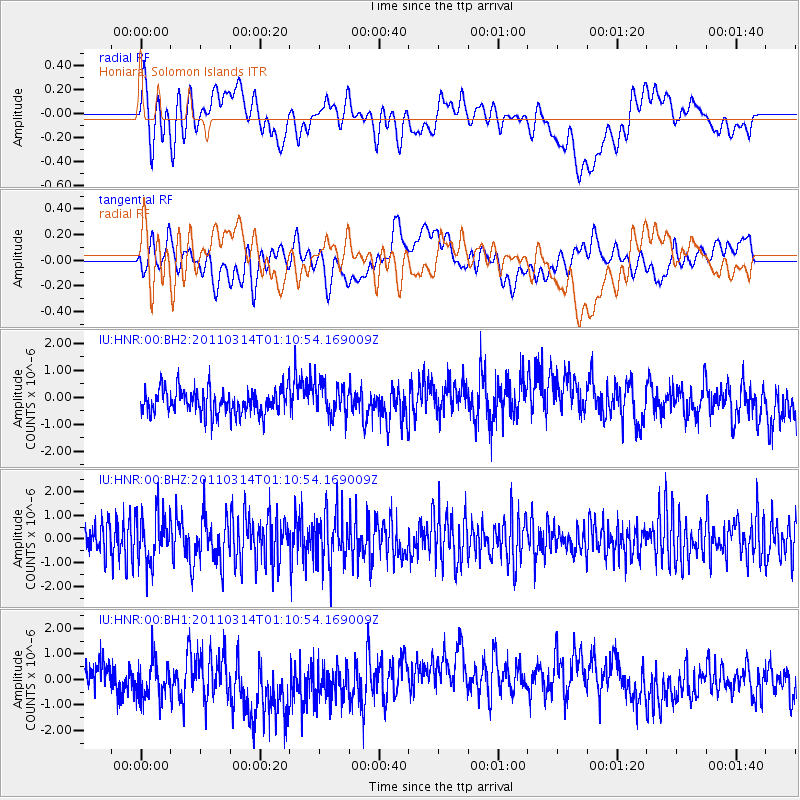
HNR Honiara, Solomon Islands - Earthquake Result Viewer
*The percent match for this event was below the threshold and hence no stack was calculated.
| Earthquake location: |
Near East Coast Of Honshu, Japan |
| Earthquake latitude/longitude: |
36.4/140.9 |
| Earthquake time(UTC): |
2011/03/14 (073) 01:02:38 GMT |
| Earthquake Depth: |
11 km |
| Earthquake Magnitude: |
6.0 MB, 5.6 MS, 5.7 MW, 5.5 MW |
| Earthquake Catalog/Contributor: |
WHDF/NEIC |
|
| Network: |
IU Global Seismograph Network (GSN - IRIS/USGS) |
| Station: |
HNR Honiara, Solomon Islands |
| Lat/Lon: |
9.44 S/159.95 E |
| Elevation: |
100 m |
|
| Distance: |
49.0 deg |
| Az: |
154.738 deg |
| Baz: |
339.578 deg |
| Ray Param: |
$rayparam |
*The percent match for this event was below the threshold and hence was not used in the summary stack. |
|
| Radial Match: |
42.238876 % |
| Radial Bump: |
400 |
| Transverse Match: |
51.94361 % |
| Transverse Bump: |
400 |
| SOD ConfigId: |
558545 |
| Insert Time: |
2013-09-18 13:49:12.398 +0000 |
| GWidth: |
2.5 |
| Max Bumps: |
400 |
| Tol: |
0.001 |
|
Signal To Noise
| Channel | StoN | STA | LTA |
| IU:HNR:00:BHZ:20110314T01:10:54.169009Z | 1.9708923 | 1.0393579E-6 | 5.2735396E-7 |
| IU:HNR:00:BH1:20110314T01:10:54.169009Z | 1.4679892 | 9.0252973E-7 | 6.148068E-7 |
| IU:HNR:00:BH2:20110314T01:10:54.169009Z | 1.2615273 | 5.924036E-7 | 4.6959232E-7 |
| Arrivals |
| Ps | |
| PpPs | |
| PsPs/PpSs | |


