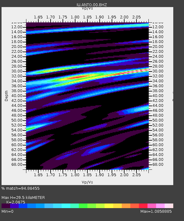
ANTO Ankara, Turkey - Earthquake Result Viewer

Earthquake location: Off East Coast Of Honshu, Japan
Earthquake latitude/longitude: 37.8/142.5
Earthquake time(UTC): 2011/03/14 (073) 06:12:36 GMT
Earthquake Depth: 14 km
Earthquake Magnitude: 6.0 MW, 5.9 MS, 6.0 MB, 6.0 MW
Earthquake Catalog/Contributor: NEIC PDE/NEIC PDE-M
Network: IU Global Seismograph Network (GSN - IRIS/USGS)
Station: ANTO Ankara, Turkey
Lat/Lon: 39.87 N/32.79 E
Elevation: 1090 m
Distance: 79.4 deg
Az: 312.489 deg
Baz: 49.387 deg
Ray Param: 0.048996497
Estimated Moho Depth: 29.5 km
Estimated Crust Vp/Vs: 2.07
Assumed Crust Vp: 6.159 km/s
Estimated Crust Vs: 2.979 km/s
Estimated Crust Poisson's Ratio: 0.35
Radial Match: 94.86455 %
Radial Bump: 400
Transverse Match: 87.598495 %
Transverse Bump: 400
SOD ConfigId: 558545
Insert Time: 2013-09-18 13:51:44.422 +0000
GWidth: 2.5
Max Bumps: 400
Tol: 0.001

Signal To Noise

ChannelStoNSTALTA
IU:ANTO:00:BHZ:20110314T06:24:10.068972Z21.3907151.164262E-65.4428384E-8
IU:ANTO:00:BH1:20110314T06:24:10.068972Z11.2416663.036109E-72.7007644E-8
IU:ANTO:00:BH2:20110314T06:24:10.068972Z9.743483.4406096E-73.531192E-8
Arrivals
Ps5.2 SECOND
PpPs14 SECOND
PsPs/PpSs20 SECOND