You are here: Home > Network List > IU - Global Seismograph Network (GSN - IRIS/USGS) Stations List
> Station POHA Pohakuloa, Hawaii, USA > Earthquake Result Viewer
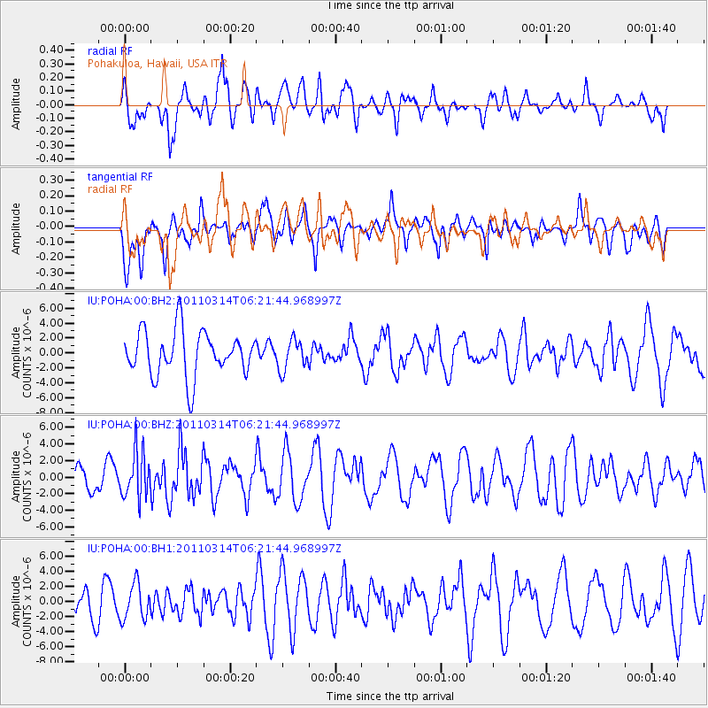
POHA Pohakuloa, Hawaii, USA - Earthquake Result Viewer
*The percent match for this event was below the threshold and hence no stack was calculated.
| Earthquake location: |
Off East Coast Of Honshu, Japan |
| Earthquake latitude/longitude: |
37.8/142.5 |
| Earthquake time(UTC): |
2011/03/14 (073) 06:12:36 GMT |
| Earthquake Depth: |
14 km |
| Earthquake Magnitude: |
6.0 MW, 5.9 MS, 6.0 MB, 6.0 MW |
| Earthquake Catalog/Contributor: |
NEIC PDE/NEIC PDE-M |
|
| Network: |
IU Global Seismograph Network (GSN - IRIS/USGS) |
| Station: |
POHA Pohakuloa, Hawaii, USA |
| Lat/Lon: |
19.76 N/155.53 W |
| Elevation: |
1990 m |
|
| Distance: |
56.3 deg |
| Az: |
90.237 deg |
| Baz: |
302.732 deg |
| Ray Param: |
$rayparam |
*The percent match for this event was below the threshold and hence was not used in the summary stack. |
|
| Radial Match: |
61.464417 % |
| Radial Bump: |
400 |
| Transverse Match: |
48.17969 % |
| Transverse Bump: |
368 |
| SOD ConfigId: |
558545 |
| Insert Time: |
2013-09-18 13:52:17.795 +0000 |
| GWidth: |
2.5 |
| Max Bumps: |
400 |
| Tol: |
0.001 |
|
Signal To Noise
| Channel | StoN | STA | LTA |
| IU:POHA:00:BHZ:20110314T06:21:44.968997Z | 2.2821653 | 2.83129E-6 | 1.2406157E-6 |
| IU:POHA:00:BH1:20110314T06:21:44.968997Z | 1.192953 | 2.395064E-6 | 2.0076768E-6 |
| IU:POHA:00:BH2:20110314T06:21:44.968997Z | 0.6780402 | 2.044992E-6 | 3.0160338E-6 |
| Arrivals |
| Ps | |
| PpPs | |
| PsPs/PpSs | |


