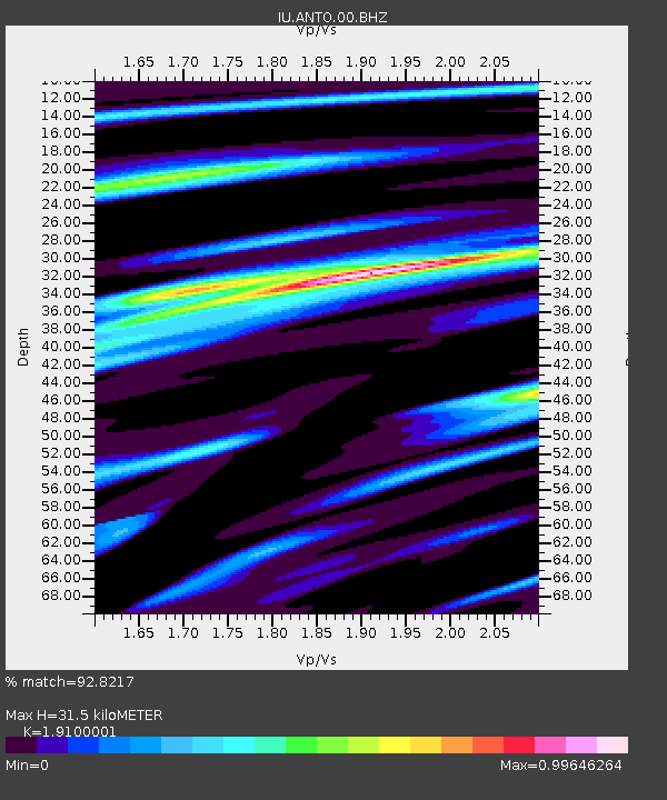
ANTO Ankara, Turkey - Earthquake Result Viewer
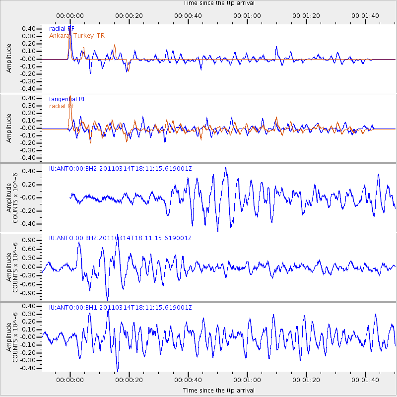
Earthquake location: Off East Coast Of Honshu, Japan
Earthquake latitude/longitude: 37.2/142.2
Earthquake time(UTC): 2011/03/14 (073) 17:59:41 GMT
Earthquake Depth: 20 km
Earthquake Magnitude: 5.7 MW, 5.4 MS, 5.4 MB, 5.6 MW
Earthquake Catalog/Contributor: WHDF/NEIC
Network: IU Global Seismograph Network (GSN - IRIS/USGS)
Station: ANTO Ankara, Turkey
Lat/Lon: 39.87 N/32.79 E
Elevation: 1090 m
Distance: 79.6 deg
Az: 312.462 deg
Baz: 49.935 deg
Ray Param: 0.048802234
Estimated Moho Depth: 31.5 km
Estimated Crust Vp/Vs: 1.91
Assumed Crust Vp: 6.159 km/s
Estimated Crust Vs: 3.224 km/s
Estimated Crust Poisson's Ratio: 0.31
Radial Match: 92.8217 %
Radial Bump: 387
Transverse Match: 89.62475 %
Transverse Bump: 400
SOD ConfigId: 558545
Insert Time: 2013-09-18 13:53:17.660 +0000
GWidth: 2.5
Max Bumps: 400
Tol: 0.001

Signal To Noise

ChannelStoNSTALTA
IU:ANTO:00:BHZ:20110314T18:11:15.619001Z6.14263253.6935768E-76.01302E-8
IU:ANTO:00:BH1:20110314T18:11:15.619001Z3.1612341.10891705E-73.5078614E-8
IU:ANTO:00:BH2:20110314T18:11:15.619001Z3.21626931.1946128E-73.7142808E-8
Arrivals
Ps4.8 SECOND
PpPs15 SECOND
PsPs/PpSs19 SECOND