You are here: Home > Network List > II - Global Seismograph Network (GSN - IRIS/IDA) Stations List
> Station WRAB Tennant Creek, NT, Australia > Earthquake Result Viewer
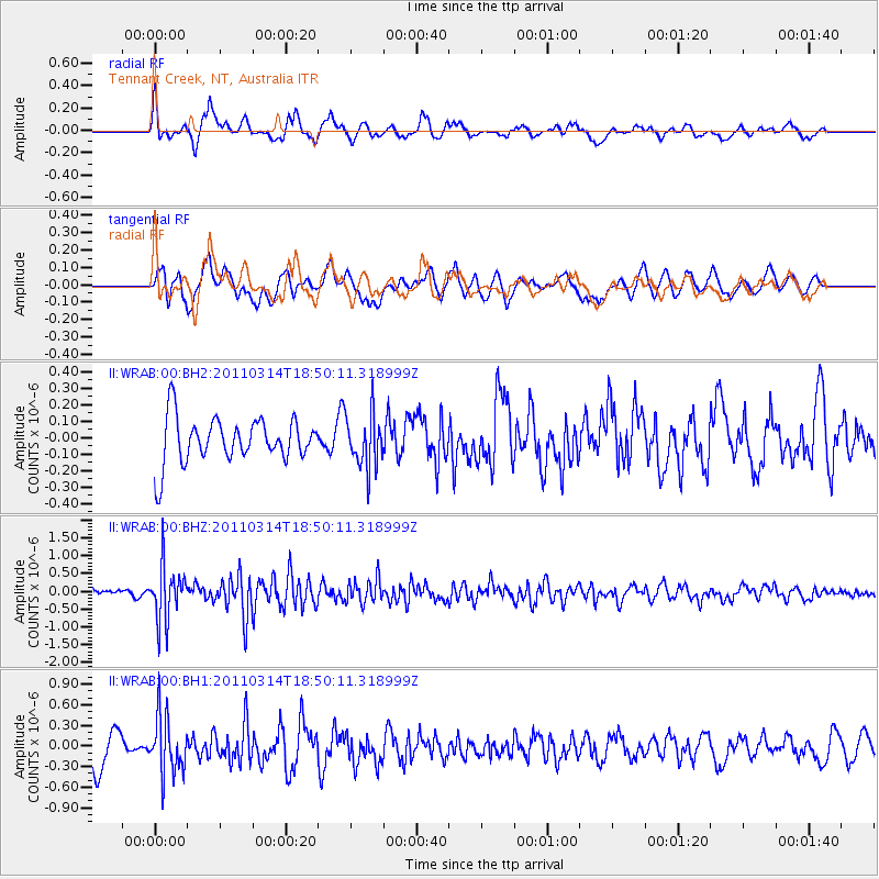
WRAB Tennant Creek, NT, Australia - Earthquake Result Viewer
*The percent match for this event was below the threshold and hence no stack was calculated.
| Earthquake location: |
Near East Coast Of Honshu, Japan |
| Earthquake latitude/longitude: |
36.6/141.7 |
| Earthquake time(UTC): |
2011/03/14 (073) 18:41:01 GMT |
| Earthquake Depth: |
26 km |
| Earthquake Magnitude: |
5.6 MB, 5.4 MW |
| Earthquake Catalog/Contributor: |
WHDF/NEIC |
|
| Network: |
II Global Seismograph Network (GSN - IRIS/IDA) |
| Station: |
WRAB Tennant Creek, NT, Australia |
| Lat/Lon: |
19.93 S/134.36 E |
| Elevation: |
366 m |
|
| Distance: |
56.6 deg |
| Az: |
188.325 deg |
| Baz: |
7.117 deg |
| Ray Param: |
$rayparam |
*The percent match for this event was below the threshold and hence was not used in the summary stack. |
|
| Radial Match: |
62.67672 % |
| Radial Bump: |
341 |
| Transverse Match: |
57.711647 % |
| Transverse Bump: |
400 |
| SOD ConfigId: |
558545 |
| Insert Time: |
2013-09-18 13:54:26.571 +0000 |
| GWidth: |
2.5 |
| Max Bumps: |
400 |
| Tol: |
0.001 |
|
Signal To Noise
| Channel | StoN | STA | LTA |
| II:WRAB:00:BHZ:20110314T18:50:11.318999Z | 6.698143 | 7.6081307E-7 | 1.1358567E-7 |
| II:WRAB:00:BH1:20110314T18:50:11.318999Z | 2.159105 | 4.2233822E-7 | 1.95608E-7 |
| II:WRAB:00:BH2:20110314T18:50:11.318999Z | 1.2074388 | 1.6521473E-7 | 1.3683072E-7 |
| Arrivals |
| Ps | |
| PpPs | |
| PsPs/PpSs | |


