You are here: Home > Network List > IU - Global Seismograph Network (GSN - IRIS/USGS) Stations List
> Station PMG Port Moresby, New Guinea > Earthquake Result Viewer
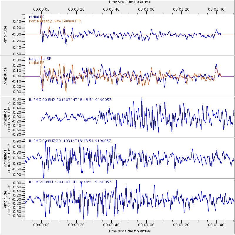
PMG Port Moresby, New Guinea - Earthquake Result Viewer
*The percent match for this event was below the threshold and hence no stack was calculated.
| Earthquake location: |
Near East Coast Of Honshu, Japan |
| Earthquake latitude/longitude: |
36.6/141.7 |
| Earthquake time(UTC): |
2011/03/14 (073) 18:41:01 GMT |
| Earthquake Depth: |
26 km |
| Earthquake Magnitude: |
5.6 MB, 5.4 MW |
| Earthquake Catalog/Contributor: |
WHDF/NEIC |
|
| Network: |
IU Global Seismograph Network (GSN - IRIS/USGS) |
| Station: |
PMG Port Moresby, New Guinea |
| Lat/Lon: |
9.40 S/147.16 E |
| Elevation: |
90 m |
|
| Distance: |
46.0 deg |
| Az: |
172.565 deg |
| Baz: |
353.94 deg |
| Ray Param: |
$rayparam |
*The percent match for this event was below the threshold and hence was not used in the summary stack. |
|
| Radial Match: |
66.94594 % |
| Radial Bump: |
400 |
| Transverse Match: |
69.11275 % |
| Transverse Bump: |
400 |
| SOD ConfigId: |
558545 |
| Insert Time: |
2013-09-18 13:54:44.956 +0000 |
| GWidth: |
2.5 |
| Max Bumps: |
400 |
| Tol: |
0.001 |
|
Signal To Noise
| Channel | StoN | STA | LTA |
| IU:PMG:00:BHZ:20110314T18:48:51.919005Z | 3.853711 | 4.81496E-7 | 1.2494345E-7 |
| IU:PMG:00:BH1:20110314T18:48:51.919005Z | 3.5500815 | 3.2473608E-7 | 9.1472856E-8 |
| IU:PMG:00:BH2:20110314T18:48:51.919005Z | 1.4943649 | 1.4288538E-7 | 9.561612E-8 |
| Arrivals |
| Ps | |
| PpPs | |
| PsPs/PpSs | |


