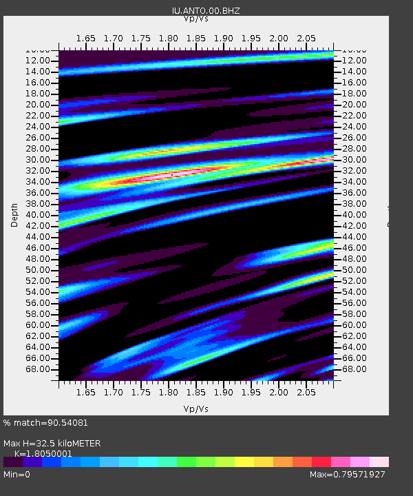
ANTO Ankara, Turkey - Earthquake Result Viewer

Earthquake location: Off East Coast Of Honshu, Japan
Earthquake latitude/longitude: 37.4/142.3
Earthquake time(UTC): 2011/03/15 (074) 09:49:52 GMT
Earthquake Depth: 8.0 km
Earthquake Magnitude: 5.8 MW, 5.6 MS, 5.8 MW, 6.0 MB
Earthquake Catalog/Contributor: NEIC PDE/NEIC PDE-M
Network: IU Global Seismograph Network (GSN - IRIS/USGS)
Station: ANTO Ankara, Turkey
Lat/Lon: 39.87 N/32.79 E
Elevation: 1090 m
Distance: 79.6 deg
Az: 312.468 deg
Baz: 49.784 deg
Ray Param: 0.048876587
Estimated Moho Depth: 32.5 km
Estimated Crust Vp/Vs: 1.81
Assumed Crust Vp: 6.159 km/s
Estimated Crust Vs: 3.412 km/s
Estimated Crust Poisson's Ratio: 0.28
Radial Match: 90.54081 %
Radial Bump: 400
Transverse Match: 90.41045 %
Transverse Bump: 400
SOD ConfigId: 558545
Insert Time: 2013-09-18 13:55:40.064 +0000
GWidth: 2.5
Max Bumps: 400
Tol: 0.001

Signal To Noise

ChannelStoNSTALTA
IU:ANTO:00:BHZ:20110315T10:01:28.668992Z13.8186036.8492164E-74.9565188E-8
IU:ANTO:00:BH1:20110315T10:01:28.668992Z4.5310391.9440898E-74.2906045E-8
IU:ANTO:00:BH2:20110315T10:01:28.668992Z2.77974751.5116922E-75.4382358E-8
Arrivals
Ps4.4 SECOND
PpPs14 SECOND
PsPs/PpSs19 SECOND