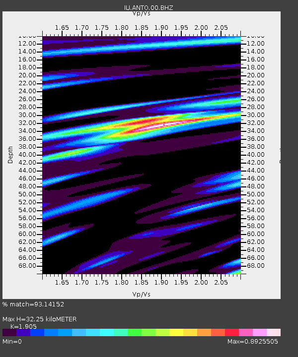
ANTO Ankara, Turkey - Earthquake Result Viewer
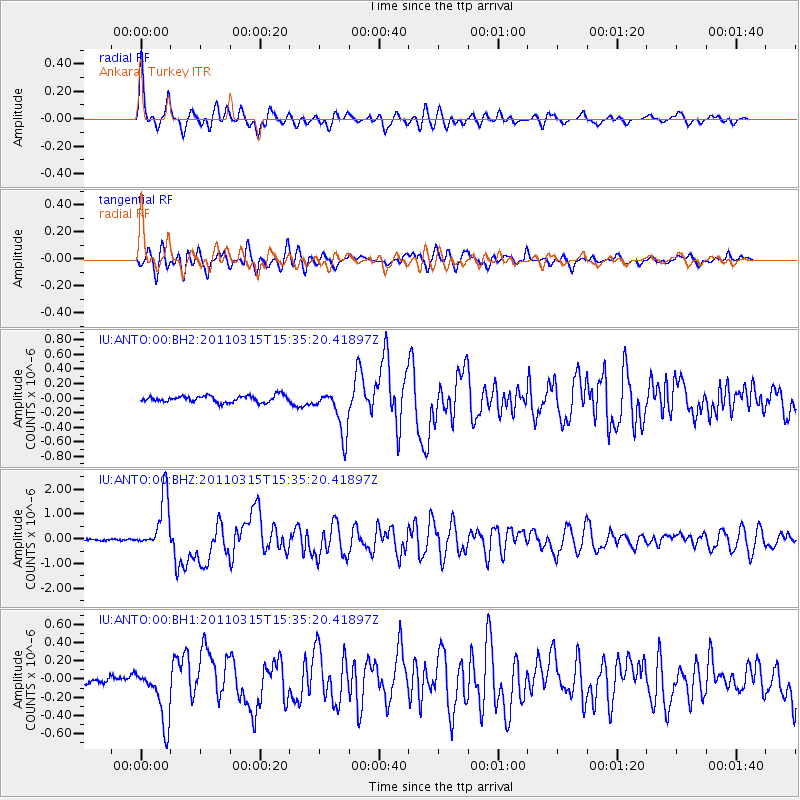
Earthquake location: Off East Coast Of Honshu, Japan
Earthquake latitude/longitude: 40.3/143.3
Earthquake time(UTC): 2011/03/15 (074) 15:23:53 GMT
Earthquake Depth: 18 km
Earthquake Magnitude: 6.1 MW, 5.6 MB, 5.9 MS, 6.1 MW
Earthquake Catalog/Contributor: NEIC PDE/NEIC PDE-M
Network: IU Global Seismograph Network (GSN - IRIS/USGS)
Station: ANTO Ankara, Turkey
Lat/Lon: 39.87 N/32.79 E
Elevation: 1090 m
Distance: 78.1 deg
Az: 312.551 deg
Baz: 47.027 deg
Ray Param: 0.049835384
Estimated Moho Depth: 32.25 km
Estimated Crust Vp/Vs: 1.90
Assumed Crust Vp: 6.159 km/s
Estimated Crust Vs: 3.233 km/s
Estimated Crust Poisson's Ratio: 0.31
Radial Match: 93.14152 %
Radial Bump: 400
Transverse Match: 86.02002 %
Transverse Bump: 400
SOD ConfigId: 558545
Insert Time: 2013-09-18 14:00:46.902 +0000
GWidth: 2.5
Max Bumps: 400
Tol: 0.001

Signal To Noise

ChannelStoNSTALTA
IU:ANTO:00:BHZ:20110315T15:35:20.41897Z20.5983331.0906883E-65.295032E-8
IU:ANTO:00:BH1:20110315T15:35:20.41897Z6.9655873.0360798E-74.3586844E-8
IU:ANTO:00:BH2:20110315T15:35:20.41897Z6.96323.154988E-74.5309456E-8
Arrivals
Ps4.9 SECOND
PpPs15 SECOND
PsPs/PpSs20 SECOND