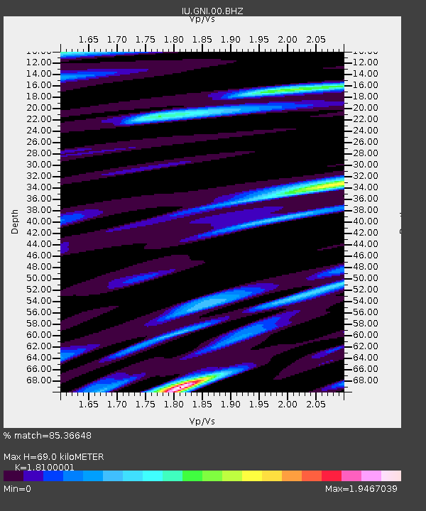
GNI Garni, Armenia - Earthquake Result Viewer
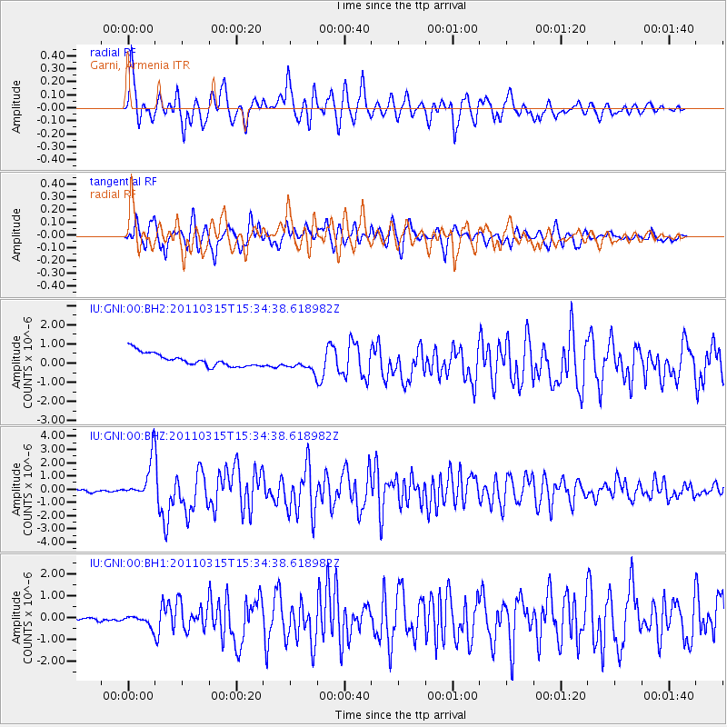
Earthquake location: Off East Coast Of Honshu, Japan
Earthquake latitude/longitude: 40.3/143.3
Earthquake time(UTC): 2011/03/15 (074) 15:23:53 GMT
Earthquake Depth: 18 km
Earthquake Magnitude: 6.1 MW, 5.6 MB, 5.9 MS, 6.1 MW
Earthquake Catalog/Contributor: NEIC PDE/NEIC PDE-M
Network: IU Global Seismograph Network (GSN - IRIS/USGS)
Station: GNI Garni, Armenia
Lat/Lon: 40.15 N/44.74 E
Elevation: 1609 m
Distance: 70.9 deg
Az: 306.67 deg
Baz: 53.12 deg
Ray Param: 0.054651182
Estimated Moho Depth: 69.0 km
Estimated Crust Vp/Vs: 1.81
Assumed Crust Vp: 6.291 km/s
Estimated Crust Vs: 3.476 km/s
Estimated Crust Poisson's Ratio: 0.28
Radial Match: 85.36648 %
Radial Bump: 400
Transverse Match: 77.09097 %
Transverse Bump: 400
SOD ConfigId: 558545
Insert Time: 2013-09-18 14:00:54.076 +0000
GWidth: 2.5
Max Bumps: 400
Tol: 0.001

Signal To Noise

ChannelStoNSTALTA
IU:GNI:00:BHZ:20110315T15:34:38.618982Z18.5577221.4959334E-68.0609745E-8
IU:GNI:00:BH1:20110315T15:34:38.618982Z3.7417082.393037E-76.395573E-8
IU:GNI:00:BH2:20110315T15:34:38.618982Z1.23984354.2342936E-73.4151842E-7
Arrivals
Ps9.2 SECOND
PpPs30 SECOND
PsPs/PpSs39 SECOND