You are here: Home > Network List > IU - Global Seismograph Network (GSN - IRIS/USGS) Stations List
> Station PMG Port Moresby, New Guinea > Earthquake Result Viewer
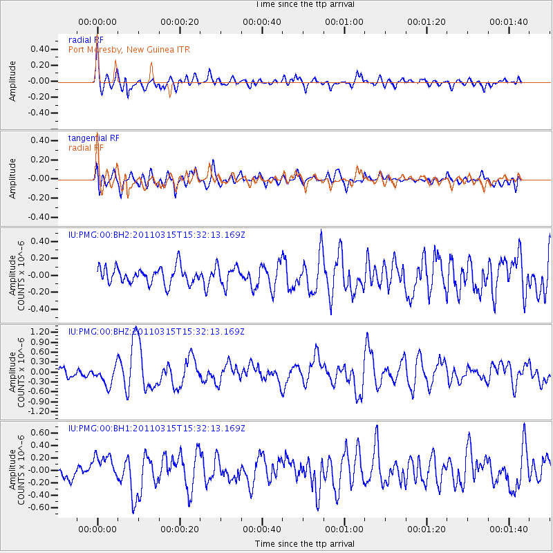
PMG Port Moresby, New Guinea - Earthquake Result Viewer
*The percent match for this event was below the threshold and hence no stack was calculated.
| Earthquake location: |
Off East Coast Of Honshu, Japan |
| Earthquake latitude/longitude: |
40.3/143.3 |
| Earthquake time(UTC): |
2011/03/15 (074) 15:23:53 GMT |
| Earthquake Depth: |
18 km |
| Earthquake Magnitude: |
6.1 MW, 5.6 MB, 5.9 MS, 6.1 MW |
| Earthquake Catalog/Contributor: |
NEIC PDE/NEIC PDE-M |
|
| Network: |
IU Global Seismograph Network (GSN - IRIS/USGS) |
| Station: |
PMG Port Moresby, New Guinea |
| Lat/Lon: |
9.40 S/147.16 E |
| Elevation: |
90 m |
|
| Distance: |
49.6 deg |
| Az: |
174.982 deg |
| Baz: |
356.115 deg |
| Ray Param: |
$rayparam |
*The percent match for this event was below the threshold and hence was not used in the summary stack. |
|
| Radial Match: |
74.46106 % |
| Radial Bump: |
400 |
| Transverse Match: |
59.376324 % |
| Transverse Bump: |
400 |
| SOD ConfigId: |
558545 |
| Insert Time: |
2013-09-18 14:01:07.434 +0000 |
| GWidth: |
2.5 |
| Max Bumps: |
400 |
| Tol: |
0.001 |
|
Signal To Noise
| Channel | StoN | STA | LTA |
| IU:PMG:00:BHZ:20110315T15:32:13.169Z | 2.5031188 | 3.0337588E-7 | 1.2119916E-7 |
| IU:PMG:00:BH1:20110315T15:32:13.169Z | 2.6038547 | 2.2038266E-7 | 8.463708E-8 |
| IU:PMG:00:BH2:20110315T15:32:13.169Z | 1.1878612 | 1.14692384E-7 | 9.65537E-8 |
| Arrivals |
| Ps | |
| PpPs | |
| PsPs/PpSs | |


