You are here: Home > Network List > IU - Global Seismograph Network (GSN - IRIS/USGS) Stations List
> Station PMG Port Moresby, New Guinea > Earthquake Result Viewer
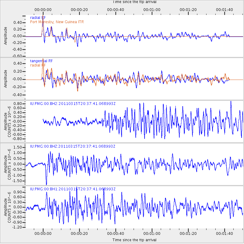
PMG Port Moresby, New Guinea - Earthquake Result Viewer
*The percent match for this event was below the threshold and hence no stack was calculated.
| Earthquake location: |
Near East Coast Of Honshu, Japan |
| Earthquake latitude/longitude: |
35.2/141.0 |
| Earthquake time(UTC): |
2011/03/15 (074) 20:29:59 GMT |
| Earthquake Depth: |
19 km |
| Earthquake Magnitude: |
5.7 MW, 5.6 MW, 5.6 MB |
| Earthquake Catalog/Contributor: |
NEIC PDE/NEIC PDE-M |
|
| Network: |
IU Global Seismograph Network (GSN - IRIS/USGS) |
| Station: |
PMG Port Moresby, New Guinea |
| Lat/Lon: |
9.40 S/147.16 E |
| Elevation: |
90 m |
|
| Distance: |
44.8 deg |
| Az: |
171.342 deg |
| Baz: |
352.824 deg |
| Ray Param: |
$rayparam |
*The percent match for this event was below the threshold and hence was not used in the summary stack. |
|
| Radial Match: |
73.798996 % |
| Radial Bump: |
400 |
| Transverse Match: |
65.88749 % |
| Transverse Bump: |
400 |
| SOD ConfigId: |
558545 |
| Insert Time: |
2013-09-18 14:02:21.443 +0000 |
| GWidth: |
2.5 |
| Max Bumps: |
400 |
| Tol: |
0.001 |
|
Signal To Noise
| Channel | StoN | STA | LTA |
| IU:PMG:00:BHZ:20110315T20:37:41.068993Z | 6.7376595 | 6.5453577E-7 | 9.714587E-8 |
| IU:PMG:00:BH1:20110315T20:37:41.068993Z | 3.7023077 | 3.441999E-7 | 9.296901E-8 |
| IU:PMG:00:BH2:20110315T20:37:41.068993Z | 1.7195233 | 1.621736E-7 | 9.4313116E-8 |
| Arrivals |
| Ps | |
| PpPs | |
| PsPs/PpSs | |


