You are here: Home > Network List > CN - Canadian National Seismograph Network Stations List
> Station FRB IQALUIT, N.W.T. > Earthquake Result Viewer
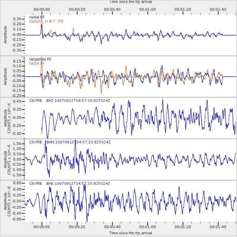
FRB IQALUIT, N.W.T. - Earthquake Result Viewer
*The percent match for this event was below the threshold and hence no stack was calculated.
| Earthquake location: |
Southwestern Ryukyu Isl., Japan |
| Earthquake latitude/longitude: |
25.0/125.8 |
| Earthquake time(UTC): |
1997/08/13 (225) 04:45:04 GMT |
| Earthquake Depth: |
55 km |
| Earthquake Magnitude: |
6.0 MB, 5.6 MS, 6.1 UNKNOWN, 6.1 MW |
| Earthquake Catalog/Contributor: |
WHDF/NEIC |
|
| Network: |
CN Canadian National Seismograph Network |
| Station: |
FRB IQALUIT, N.W.T. |
| Lat/Lon: |
63.75 N/68.55 W |
| Elevation: |
18 m |
|
| Distance: |
90.8 deg |
| Az: |
6.314 deg |
| Baz: |
347.035 deg |
| Ray Param: |
$rayparam |
*The percent match for this event was below the threshold and hence was not used in the summary stack. |
|
| Radial Match: |
61.187176 % |
| Radial Bump: |
400 |
| Transverse Match: |
60.761192 % |
| Transverse Bump: |
400 |
| SOD ConfigId: |
4480 |
| Insert Time: |
2010-02-27 05:53:51.179 +0000 |
| GWidth: |
2.5 |
| Max Bumps: |
400 |
| Tol: |
0.001 |
|
Signal To Noise
| Channel | StoN | STA | LTA |
| CN:FRB: :BHN:19970813T04:57:30.825024Z | 3.3339448 | 8.256121E-7 | 2.476382E-7 |
| CN:FRB: :BHE:19970813T04:57:30.825024Z | 3.4169693 | 2.8538167E-7 | 8.351895E-8 |
| CN:FRB: :BHZ:19970813T04:57:30.825024Z | 1.0797331 | 1.5724528E-7 | 1.4563346E-7 |
| Arrivals |
| Ps | |
| PpPs | |
| PsPs/PpSs | |


