You are here: Home > Network List > IU - Global Seismograph Network (GSN - IRIS/USGS) Stations List
> Station HNR Honiara, Solomon Islands > Earthquake Result Viewer
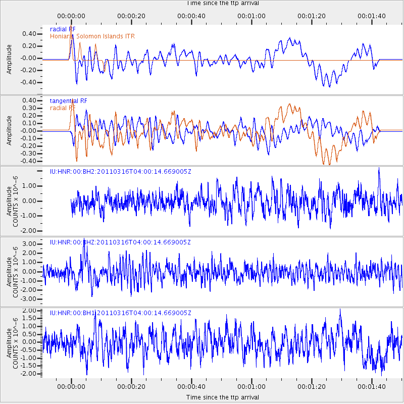
HNR Honiara, Solomon Islands - Earthquake Result Viewer
*The percent match for this event was below the threshold and hence no stack was calculated.
| Earthquake location: |
Near East Coast Of Honshu, Japan |
| Earthquake latitude/longitude: |
35.7/140.7 |
| Earthquake time(UTC): |
2011/03/16 (075) 03:52:02 GMT |
| Earthquake Depth: |
10 km |
| Earthquake Magnitude: |
5.7 MW, 5.5 MS, 5.8 MW, 6.0 MB |
| Earthquake Catalog/Contributor: |
NEIC PDE/NEIC PDE-M |
|
| Network: |
IU Global Seismograph Network (GSN - IRIS/USGS) |
| Station: |
HNR Honiara, Solomon Islands |
| Lat/Lon: |
9.44 S/159.95 E |
| Elevation: |
100 m |
|
| Distance: |
48.5 deg |
| Az: |
154.262 deg |
| Baz: |
339.021 deg |
| Ray Param: |
$rayparam |
*The percent match for this event was below the threshold and hence was not used in the summary stack. |
|
| Radial Match: |
60.955715 % |
| Radial Bump: |
400 |
| Transverse Match: |
64.79109 % |
| Transverse Bump: |
400 |
| SOD ConfigId: |
558545 |
| Insert Time: |
2013-09-18 14:03:40.803 +0000 |
| GWidth: |
2.5 |
| Max Bumps: |
400 |
| Tol: |
0.001 |
|
Signal To Noise
| Channel | StoN | STA | LTA |
| IU:HNR:00:BHZ:20110316T04:00:14.669005Z | 2.3708072 | 1.3045193E-6 | 5.5024265E-7 |
| IU:HNR:00:BH1:20110316T04:00:14.669005Z | 1.4130322 | 5.5777383E-7 | 3.9473542E-7 |
| IU:HNR:00:BH2:20110316T04:00:14.669005Z | 0.82039124 | 3.4582447E-7 | 4.2153604E-7 |
| Arrivals |
| Ps | |
| PpPs | |
| PsPs/PpSs | |


